Select Page
David L. Revell, Ph.D.
Principal, Coastal Climate Risk and Resilience

David L. Revell, Ph.D.

Principal, Coastal Climate Risk and Resilience

Dr. David Revell is a coastal geomorphologist with more than 25 years of experience studying marine, coastal, and estuarine processes, working to integrate science and management of coastal processes and climate change. He has served as a technical advisor and facilitator to multiple federal, state, and local jurisdictions related to ocean and coastal management especially at the intersection of how physical processes and human alterations affect hazards, habitats, and human use. He has been involved in a wide variety of contentious community stakeholder processes ranging from evaluating erosion hazard alternatives to climate change vulnerability impacts to lagoon and fisheries management...

Dr. David Revell is a coastal geomorphologist with more than 25 years of experience studying marine, coastal, and estuarine processes, working to integrate science and management of coastal processes and climate change. He has served as a technical advisor and facilitator to multiple federal, state, and local jurisdictions related to ocean and coastal management especially at the intersection of how physical processes and human alterations affect hazards, habitats, and human use. He has been involved in a wide variety of contentious community stakeholder processes ranging from evaluating erosion hazard alternatives to climate change vulnerability impacts to lagoon and fisheries management, water quality, and marine spatial planning. Much of his work involves physical process research and spatial analysis to facilitate communication of science to inform decision-making. Dr. Revell currently advises multiple local jurisdictions and agencies on dune and sediment management, climate change, estuary processes, inlet management, and local coastal program updates.
Read More    Read Less   

Vulnerability & Adaptation Planning

West Cliff Drive Adaptation and Management Plan, Santa Cruz, California Developing a neighborhood scale/transportation corridor adaptation plan along iconic West Cliff Drive in Santa Cruz, balancing coastal erosion, transportation, recreation, and community visioning. Specific work tasks included hazard modeling, local coastal program policy development, and social vulnerability and economic and engineering analyses. A substantial public outreach included a technical advisory committee, focus groups, and other stakeholders to identify different community adaptation visions to be evaluated by all disciplines to identify the most effective adaptation pathways through time and to develop land use policies to integrate into local coastal and city planning documents. Led a diverse team of geologists, engineers, economists, ecologists, and transportation planners on the project.
Statewide Synthesis of Public Trust Sea Level Rise Reports, California Reviewing and synthesizing all of the legislatively mandated AB 691 sea level rise reports for the California State Lands Commission. These reports were required from grantees of subtidal and intertidal public trust resources and included vulnerabilities, economic impacts, and potential adaptation strategies for a host of ports, harbors, and wharves in California. Each report was evaluated for completeness, common themes in vulnerabilities, adaptation approaches, and economic ramifications. A statewide synthesis report will be developed and submitted to the legislature which will include making recommendations on future funding streams and legislative actions to guide future California public trust adaptation investments.
Vulnerability Assessment for Power Generating Stations, City of Oxnard, California Served as an expert witness to conduct a vulnerability assessment for the energy and infrastructure facilities within the coastal zone in the City of Oxnard from current and future coastal hazards. The assessment employed a variety of modeling work completed as part of the Nature Conservancy’s Coastal Resilience Ventura project. This assessment provides the City with information to review the California Energy Commission application for additional energy development at the Mandalay Generating Station. The vulnerability assessment also bolsters the City’s understanding of the timing and failure of the Ormond Beach Generating Station as the City considers methods to remove aging energy infrastructure.
Natural Gas and Electricity Vulnerability Assessment for the San Diego Region, California As part of the 4th California Climate Assessment, led the coastal hazard and sea level rise assessment for the SoCal Natural Gas and San Diego Gas and Electric Utility infrastructure. Work included evaluation of COSMOS 3.0 modeling, U.S. Department of Defense hazard modeling, and integration of all modeling initiatives into the vulnerability assessment by filling data gaps and interpreting the modeling results.
Poseidon Desalination Plant, Huntington Beach, California Evaluated current and existing hazards to a proposed desalination plant in Huntington Beach, California. Projections to the proposed facility were evaluated as well as cumulative impacts to the surrounding community. Work included evaluating and interpreting existing modeling, reviewing engineering designs, permit conditions, mapping, and report writing. Future work will include agency consultation and meeting attendance.
Sea Level Rise Study, Imperial Beach, San Diego, California Teaming with USC Sea Grant, conducted a sea level rise vulnerability and adaptation study in Imperial Beach, San Diego, California. With funding from the State Coastal Conservancy, led the City through a facilitated process to characterize existing and future vulnerabilities, identify potential adaptation strategies, and help educate the local community to garner support for implementing of prioritized actions. An expanded scope, with San Diego Foundation funding, enabled an economic analysis and expanded educational outreach to elected officials and regional partners to be included. Part of the project built technical capacity within the City to support future incorporation of new relevant data. Key partners in the initiative are the Tijuana River National Estuarine Research Reserve, the Port of San Diego, and the U.S. Navy.
Local Coastal Program Update with Sea Level Rise, City of Marina, California With a teaming partner, updating the City of Marina Local Coastal Program (LCP) with funding from the California Coastal Commission. Work includes technical analysis, mapping, and completion of the Existing Conditions, Vulnerability, and Adaptation Plan report. Will lead stakeholder engagement on the vulnerabilities and potential adaptation strategies to the City Council, Planning Commission, and public outreach process.
Resilient Coastal Adaptation Project, Ventura County, California Conducting a vulnerability and fiscal impact study for the County of Ventura to support adaptation planning and LCP policy updates. This project includes data analysis, hazard modeling to round out data gaps in the COSMOS 3.0 and Coastal Resilience hazard modeling, integration with the economic team, and public outreach and communication.
Local Coastal Program and General Plan Update, Carpinteria, California Working with a teaming partner in updating the City of Carpinteria LCP and General Plan. Specific tasks are to conduct a vulnerability study and fiscal impact study and work with the steering committee and city to incorporate the findings into policy. This project has included data analysis, evaluation and interpretation of various Coastal Hazard model outputs (COSMOS 3.0 and Coastal Resilience), and public outreach and communication.
Local Coastal Program, City of Monterey, California As part of a consultant team, updated the City of Monterey LCP with funding from the California Coastal Commission. Work included technical analysis, hazard modeling and mapping, and completion of the Existing Conditions and Vulnerability Report. Led presentations on the vulnerabilities and potential adaptation strategies to the City Council, Planning Commission, and stakeholder engagement process.
Local Coastal Update for Sea Level Rise, Oxnard, California For the City of Oxnard, guided a teaming consultant to conduct a vulnerability study and adaptation plan in support of the LCP update. This project has included data analysis, additional adaptation modeling, integration with the economic team, and public outreach and communication.
Local Coastal Program, City of Carlsbad, California Participated on a team to support the LCP update process. Provided technical advice on interpretation of hazard modeling, adaptation, and outreach. Presented on adaptation options and wrote the sections on various adaptation strategies to community work groups, and provided scientific input to the City Council, Planning Commission, and stakeholder process including review of proposed LCP policies and implementation plan language.
Local Coastal Program, City of Pacific Grove, California Participated on a team to support the LCP update process. Work included technical analysis, hazard modeling and mapping, and outreach. Presented on various adaptation strategies to community work groups, and provided scientific input to the City Council, Planning Commission, and stakeholder process including review of proposed LCP policies and implementation plan language.
Incorporation of Climate Change into the Local Coastal Program, Goleta, California Worked for the City of Goleta to update and draft its LCP policies to include climate change impacts consistent with the California Coastal Commission Guidance on sea level rise. This work included a vulnerability assessment, a coauthored fiscal impact section, identification and evaluation of adaptation strategies to provide policy recommendation, and sections of the LCP related to coastal hazards.
Neskowin Shoreline Assessment, Neskowin, Tillamook County, Oregon In response to high rates of erosion and sea level rise that have diminished the beaches and now threatens homes and roads in Neskowin, Oregon, analyzed the viability of various coastal erosion mitigation strategies on an eroding shore, utilizing existing information from local academic institutions (Oregon State University) and agencies (including the Department of Geology and Mineral Industries). Applied experience completing assessments for similar high-energy wave-exposed coastal areas. Performed modeling to evaluate physical changes from various adaptation strategies and provided conceptual level engineering cost estimates for each strategy to inform community decision-making. The community was striving to find a balance of private property protection with maintenance of a sandy beach to support the tourist economy.
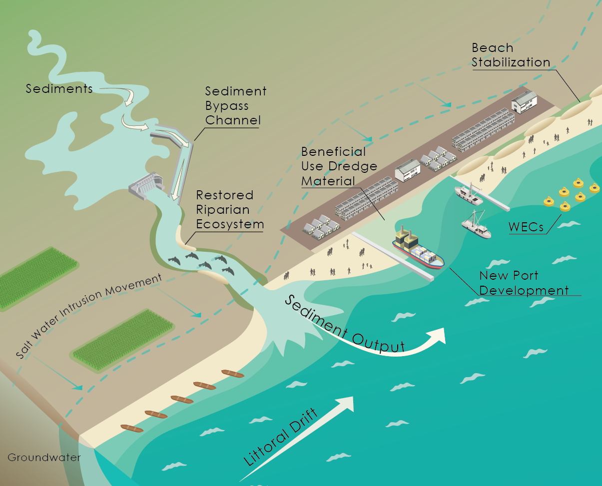
Technical Evaluation of Erosion Mitigation Alternatives and Regional Sediment Management Plan for Southern Monterey Bay, California Managed an evaluation of erosion mitigation alternatives (adaptation strategies) for Southern Monterey Bay to support development of a regional strategy to address coastal hazards. Twenty-two different erosion mitigation measures were evaluated, including land use planning tools, soft engineering solutions, and hard engineering solutions. The measures were compared using a variety of criteria including an innovative effectiveness criterion, which ranked each measure’s merit at protecting upland property and beach widths (a highly valued community resource). The study then compared the costs and benefits of each measure over multiple time horizons by tracking the physical impacts of each measure on the beach and upland through time. The holistic cost–benefit analysis included accounting for beach recreation and ecosystem services in addition to traditional storm damages. While this initial study did not include climate impacts directly, it began to inform adaptation strategies across the region.

Coastal Hazard Modeling

Pacific Institute Coastal Infrastructure and Vulnerability Impacts Assessment, California With funding from the Ocean Protection Council as part of the 2008 California Climate Impacts Assessment through the California Energy Commission, conducted the first California statewide coastal hazard assessment resulting from sea level rise. This groundbreaking project, the first of its kind on the U.S. West Coast, mapped projected future coastal erosion and coastal flooding hazards. To complete this project, developed a new methodology that evaluated geomorphic response of various backshore types by applying a total water level methodology; collaborated with climate change researchers at Scripps, USGS, and Oregon State University; organized and engaged a technical and regulatory peer review team on methods and results; and collaborated with Pacific Institute on a vulnerability assessment associated with coastal hazards, which was published in the Pacific Institute Report titled The Impacts of Sea Level Rise to the California Coast.
Monterey Bay Sea Level Rise Vulnerability Assessment, Monterey and Santa Cruz Counties, California With funding from the California Coastal Conservancy, the Natural Capital Project, and the City of Capitola, managed a project and led technical work to model projected climate change impacts to the coast of Monterey Bay at a scale suitable for planning purposes. The project was overseen by a Monterey Bay region wide technical advisory group comprising research institutions (University of California, Santa Cruz [UCSC]; Naval Postgraduate School; Moss Landing Marine Laboratories; California State University, Monterey Bay; and USGS), local planning agencies (Santa Cruz, Monterey Counties, Cities of Monterey, Santa Cruz, Seaside, Sand City, Capitola), and other technical experts. Uncertainty in the sea level rise projections were represented by mapping a variety of projected impacts and then overlapping them and developing an uncertainty index that showed relative risk of coastal hazard impacts.
The Nature Conservancy’s Coastal Resilience Program, Ventura County, California Working through an interactive stakeholder process with multiple agencies, local government representatives, and several nonprofit organizations, led a technical team that modeled current and potential future coastal and fluvial hazards for a variety of climate change scenarios, representing sea level rise and changes to rainfall and sediment delivery, for the Ventura County coastline, including Mugu Wetlands, the Santa Clara River, and the Ventura River. Applied a habitat evolution model (Sea Level Affecting Marsh Migration, SLAMM) to predict long-term wetland conversion with sea level rise, as well as to identify areas of ecological vulnerability based on potential adaptation strategies. SLAMM model results were then used to calculate the greenhouse gas emissions related to multiple adaptation strategies. Local communities and the U.S. Department of Defense are using the results to evaluate vulnerabilities and consider adaptation strategies.
Coastal Resiliency: Phases 1 and 2, Santa Barbara, California With funding from the California Coastal Commission, the Coastal Commission, and the Ocean Protection Council, modeled projected coastal hazards exacerbated by sea level rise the Santa Barbara County coast at a scale suitable for planning purposes. Deliverables included projected future coastal hazards, which include a new integrated approach of stepping through time eroding the coast and flooding newly eroded areas through hydraulic connectivity. More information on results is available at Santa Barbara County Coastal Resilience through The Nature Conservancy.
Technical Review of FEMA Coastal Flood Maps, County of Ventura, California Reviewed the recently released Preliminary Coastal Flood Insurance Rate Maps for the County of Ventura. Specific work focused on the technical review of modeling assumptions, calculations, and geomorphic interpretation to evaluate the accuracy and shortcomings of the new proposed regulatory maps. The final report has been submitted to FEMA to consider additional work to improve the mapping accuracy.
USGS–UCSC Coastal Processes Study for Santa Barbara and Ventura Counties, California Conducted research and managed the UCSC research team on a collaborative project with USGS to study large-scale coastal processes of the Santa Barbara littoral cell. Examined seasonal changes through extensive field data collection campaigns and conducted numerical modeling to further inform observations of short-term and seasonal changes and provide insights into long-term shoreline evolution.

Living Shoreline

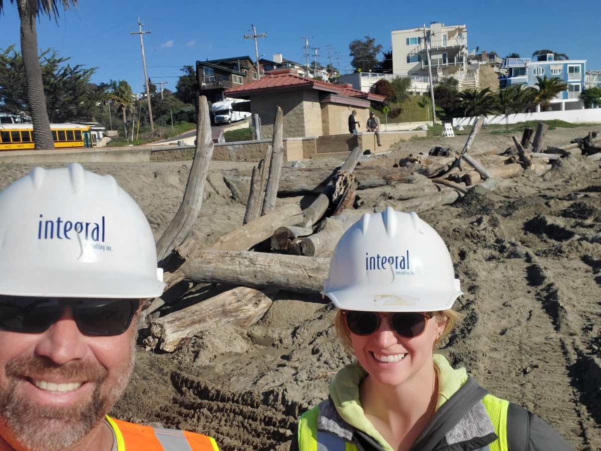
Rio Del Mar State Beach Living Shoreline Project – Santa Cruz, CA Integral working for California State Parks has designed nature-based adaptation strategies to reduce coastal erosion hazards. At Rio Del Mar State Beach in Santa Cruz, CA fluvial processes that reduce the natural buffering capacity of the beach and wave processes were driving coastal erosion that threatened a public restroom and critical sewage pump station.  Using a unique approach, Integral guided State Parks away from an expensive emergency revetment into using native materials found along the beach to provide natural protection. The design utilized large driftwood that had accumulated across the State Beach and carefully placed it into an engineered log jam to form the core of a sand dune. Design considerations included public viewsheds, beach access, and easily implemented monitoring elements.
San Lorenzo River Lagoon Management, Santa Cruz, California In collaboration with the City of Santa Cruz, working to manage the San Lorenzo River lagoon and balance often competing priorities of flood reduction, endangered species, public safety, recreation, and water quality. Extensive agency engagement has permitted a variety of different approaches to the lagoon mouth management including multiple innovative approaches to opening the lagoon mouth, while balancing often competing priorities. Work has included technical analysis, mapping, conceptual construction plans, onsite field observations, fieldwork, construction support, permitting, and report writing.
Santa Clara River Estuary: Scientific Review Panel, Ventura County, California As a member of a consent decree-appointed science advisory panel, reviewing technical reports, model results, field data, and summary reports to provide a recommendation on future wastewater discharge levels from the Ventura Wastewater Reclamation Facility. Coordinating with other scientists and consultants to develop independent scientific recommendations to support permitting, policy, and community infrastructure planning. The review panel recommendation will be used to develop Regional Water Quality Control Board permits as well as a basis for a recycled water facility in the City of Ventura.
Goleta Slough Sea Level Rise Vulnerability and Adaptation Study and Ecosystem Management Plan Update, California Managed an adaptation study to reevaluate the study area based on projected sea level rise as part of a plan to update the Goleta Slough Ecosystem Management Plan prepared by the Goleta Slough Management Committee and adopted by the City of Santa Barbara in 1997. Through a facilitated stakeholder process and technical analyses, the study assessed vulnerability and risk to both natural and human resources and infrastructure. Based on results of the vulnerability assessment, recommended a series of adaptation strategies that included both capital improvements and policy recommendations. Led the technical analyses and provided guidance and direction to subcontractors.
Goleta Beach Erosion Projects, County of Santa Barbara, California Assisting the County of Santa Barbara in multiple stakeholder processes and technical studies related to the substantial erosion to Goleta Beach County Park catalyzed by the 1997–1998 El Niño erosion wave. Studies have included peer-reviewed scientific research and technical studies on various adaptation strategies with several alternative park reconfigurations and managed retreat options. Peer-reviewed other technical modeling and led a technical team to conduct wave run-up and climate change modeling to support the Environmental Impact Report on a managed retreat strategy. Throughout the process, presented research results to stakeholder group.
Surfer’s Point Managed Retreat, Ventura, California Provided geomorphic evaluation of the site, input on the engineering and design quantities, and developed the monitoring plan for the Surfer’s Point Managed Retreat project, which included the removal of a public parking lot, nourishment of 50,000 cubic yards of cobbles, construction and planting of native dunes, and subsequent monitoring. Actively coordinating with the City of Ventura (on a volunteer basis) to ensure that sand augmentation and monitoring results are consistent with the original design concepts.
Hybrid Cobble and Dune Restoration Project, Cape Lookout State Park, Oregon Developed an erosion response plan that incorporated dune historical shoreline change analysis, El Niño changes, and geomorphological interpretation for a living shoreline hybrid cobble and dune restoration project to protect Cape Lookout State Park. The project included conceptual design, coastal processes analysis, modeling, construction management, and project monitoring. Led the coastal analysis, modeling, and conceptual design as well as provided onsite construction management of prison labor and developed the initial monitoring plan. Following completion, the monitoring program was funded by the U.S. Army Corps of Engineers as part of the Section 227 Innovative Shoreline Protection program and the Oregon Department of Geology and Mineral Industries. The living shoreline project remains effective to present day.
RETURN TO OUR TEAM PAGE