
Poster
Multiple Lines of Evidence to Support 3-Dimensional Delineation of a Historical Dredge Prism
By Logan Uselman, Ph.D., P.G., Consultant
Carolyn Huynh, Senior Scientist
Additional contribution by Debbie Deetz Silva (EVRAZ Inc. NA)
Poster presented at Battelle Sediments Conference, Jan 9-12, 2023, Austin, Texas
Background/Objectives
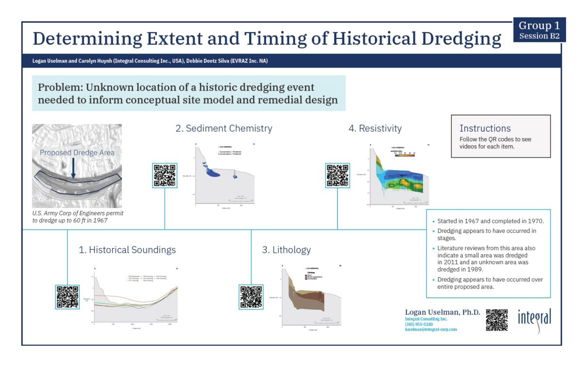
Site-specific historical documentation is not always available to inform conceptual site models. The lack of historical knowledge leaves project teams in need of employing creative solutions to recreate past events. At a project site in the Pacific Northwest, a proposal for a large fluvial dredging event was approved in 1967 by the U.S. Army Corps of Engineers. The lateral and vertical extent of this dredging event is uncertain as no as-built documentation is available. Given the suspected location of the 1967 dredge event in relation to the project site, Integral Consulting Inc. (Integral) created a 3-dimensional model of the river and nearshore area of the project site to estimate the historically dredged footprint and refine the project conceptual model.
Approach/Activities
Integral generated a 3-dimensional model using multiple lines of evidence including historical soundings, recent bathymetric surveys, subsurface sediment chemistry, lithology, and sediment resistivity. Nautical charts provided historical, discrete-point soundings recorded in 1959, 1967, 1968, and 1969 within and around the approximate dredge footprint. Each set of sounding records was converted to an approximate historical bathymetric surface using kriging interpolation in ArcGIS. Sediment cores collected through 2022 provide information on lithology and chemical concentrations. Integral interpolated chemical concentrations in three dimensions using a radial basis function algorithm in Seequent’s Leapfrog Works software (Leapfrog). Integral also created a 3-dimensional geologic model in Leapfrog from lithology observations made in 2021 and 2022. In addition, Integral oversaw a geophysical resistivity survey for the project site in 2021. Sediment types and thicknesses were determined by injecting an electrical current into the subsurface and measuring voltage gradients via electrodes towed on a submarine cable. These data sources were combined in Leapfrog to characterize subsurface sediment chemistry and physical parameters to estimate the extent of the historical dredge area.
Results/Lessons Learned
Historical bathymetric surfaces suggest that a significant dredging event occurred between 1959 and 1967/1968 in the nearshore portion of the project site in the vicinity of the approved 1967 dredge permit. A rough estimate of the lateral extent of the event was determined from the change in bathymetric surfaces. Given the rough nature of the interpolated historical bathymetric surfaces, the lateral extent was refined based on locations of similar vertical properties. A change in sediment resistivity correlating to a change in lithology from silts to poorly graded sands in the vertical direction corresponded to the location of the 1968 bathymetric surface in many locations. In addition, in the vertical direction, Integral found distinct prisms of chemical concentrations co-located with changes in lithology and resistivity. Our work showcases the use of 3-dimensional models to combine multiple lines of evidence to solve gaps in historical site knowledge.
Published
January 11, 2023

About The Author
Dr. Logan Uselman is a hydrogeologist and project manager with a focus on large legacy contamination sites and regulatory tracking.... Full bio