Mapping Dredging Residuals and Disposal Deposits
By Eugene C. Revelas, Senior Science Advisor
Nicole Ott, Principal, Hydrology, Geosciences, and Chemistry
Remediation of contaminated sediment sites often involves the dredging and disposal of sediment and debris. It is well documented that surface sediment remaining after environmental dredging operations contains elevated contaminant levels. These postdredging “residuals” may be “undisturbed residuals,” that is, contaminated sediment not removed during dredging, or “generated residuals,” sediment that is resuspended, dislodged, and released during dredging and redeposited back on the bottom, often within or near the dredging footprint.
Because of their relatively fine-grained nature and high fluidity, generated residuals can carry large contaminant loads and be transported relatively far from the dredging operations. Consequently, although effective management of residuals can be challenging, it is key to the success of a cleanup dredging project. For large, long-term projects, a statistically robust sediment sampling program (before, during, and after dredging) is required to understand the depositional fate of generated residuals. This assessment of the post-dredging distribution of contaminants at a site determines what “post-remedial remedial” actions are needed to minimize risk. Examples of potential postremedial actions include cleanup pass redredging and sand cover placements.
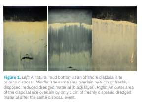
Sediment profile imaging (SPI) surveys are an underutilized but effective part of a rigorous, multifaceted sampling program. Integral can perform SPI surveys to accurately map dredged residual deposits during and immediately after environmental dredging operations. SPI technology has been used for decades to map deposits and benthic conditions at dredged material disposal sites. Because of the camera’s unique ability to capture very high-resolution images of the upper 20 cm of the sediment column, very thin (centimeterscale) depositional layers, anthropogenic or natural, can be imaged and measured (Figure 1).
When the SPI camera is deployed during or immediately after a dredge disposal operation, the freshly settled deposits are readily apparent visually and can be accurately mapped to centimeter scales in near real time. In most sedimentary settings, biological reworking quickly mixes thin deposits into the ambient bottom and the visual evidence of its presence fades within days to weeks. The 1 cm layer of dredged material in the right image below is in the process of being “erased.” That image was collected 1 week after the dredged material was disposed.
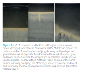
Similarly, when SPI surveys are conducted at dredging sites immediately after dredging, generated residual deposits can be readily detected (Figure 2). Rapid deployment of the SPI camera throughout and surrounding a recently completed dredging operation
with a rapid, in-field review of the imagery allows residuals distribution to be accurately mapped. Use of this high-resolution spatial information optimizes, and sometimes eliminates the need for, follow-up sediment sampling, thereby reducing costs and yielding faster results. In turn, this information can help improve best management practices associated with dredging operations themselves, and more significantly, help identify whether and what scale of targeted postremedial actions, such as sand covers or cleanup pass redredging, might be warranted.


