Using Accurate Sample Elevations to Characterize Sediment Conditions with 3-Dimensional Modeling
By Brandon C. Tufano, Senior Scientist
Kelsey Kirkland, L.G., Senior Scientist
Logan Uselman, Ph.D., P.G., Consultant
Why Recording Vertical Location in Elevation Is Preferable to Depth
Introduction
Contaminated sediment sites are complex systems with spatially and temporally variable conditions. Sediment sampling and bathymetric surveys are two common methods used to characterize these dynamic systems and provide insight into changes in sediment conditions over time. Sediment samples provide physical, lithologic, and chemistry data, whereas bathymetric surveys produce riverbed morphology data at the time of each survey. Comparisons of surveys recorded at different times provide information about where and by what magnitude areas of the riverbed/seafloor¹ experience erosion or deposition/shoaling.
Conceptual site models (CSMs) and 3 dimensional mapping software, such as Seequent’s Leapfrog® Works, are tools used to compile various data (e.g., bathymetric, lithologic, and chemistry data) and generate a multidimensional visual representation of the sediment bed. Development and use of CSMs in complex sediment sites is beneficial because they allow users to visualize the sediment bed in three dimensions and provide insight into current and historical conditions. CSMs are often used to inform risk assessments and management decisions, so it is important that they accurately reflect site conditions, particularly when key conditions are highly variable and when data have been collected over a long period of time (as is common in sediment megasites).
Surface Sediment—Why is it important and how is it defined?
The sediment bed is characterized as either surface or subsurface, and data sets are typically divided into these subsets based on the depth from which the samples are collected, or the depth interval the sample represents. How this can be different from the depth at sample collection is addressed in this article. Surface sediment is the upper layer of the sediment bed between the mudline and the bottom of the biologically active and oxygenated zone, which can be determined using sediment profile imaging. Contaminants in surface sediment can pose risks to ecological and human health through finfish and shellfish consumption. The biologically active zone, critical in determining the depth of surface sediment, is the depth to which benthic invertebrates at the base of the food chain live, and bioavailable contamination present in surface interval can accumulate particularly in the tissues of macroinvertebrates and bottom dwelling fishes (e.g., sole).
Risk assessors evaluate contaminant hazards in surface sediment (where biota are exposed to contamination), and remedial designs target often cleanup of contaminated surface sediment to reduce risk. In dynamic water bodies, the sediment constituting the surface layer can be subject to continual change, and as a result, historical data collected from the once surface sediment layer should not be assumed to represent the surface layer or its conditions in perpetuity.²
Recording Depths and Elevations
When sediment samples are collected, their vertical positions are recorded and brought into databases as an upper depth and a lower depth below the mudline (e.g., 0 to 6 in.; 1 to 2 ft). However, in dynamic water bodies subject, the recorded depth interval is only representative of conditions at the time of sample collection. For instance, in a depositional environment, a surface sediment sample collected 10 years ago could be buried multiple feet deep within the sediment bed, and thus would no longer represent surface conditions. It should not be evaluated as part of a surface sediment dataset.
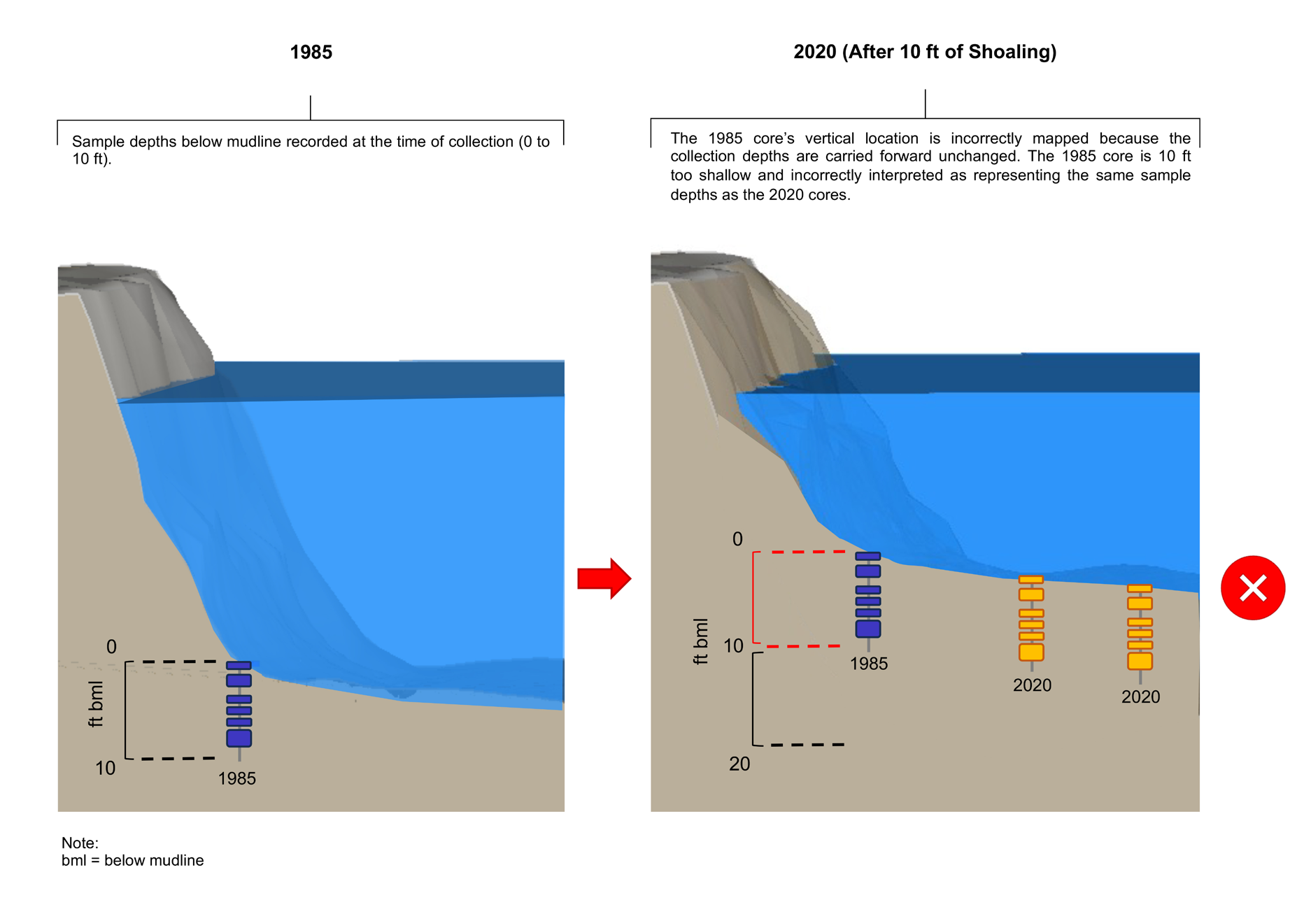
Because the mudline can be a dynamic and everchanging reference point, a depth measurement relative to this point does provide enough information about a sample’s location over time. Instead, a measurement basis that is not relative to a moving starting point (the mudline) is required. Evaluations of particular layers of the sediment bed will we erroneous if depth alone is to map data. Figure 1a shows how errors are introduced when depth alone is used to define sample location.
Figure 1a. Erroneous mapping of historical data in a depositional setting
Elevation is the static way to understand and track the vertical location of sample intervals. The elevation of the top of the core or of a grab sample can be determined in two ways:
- During sample collection, the water depth at the core/grab collection location is recorded using a lead line, fathometer, or equivalent sounding device. In a tidal water body, the tidal stage at the time of core/grab collection is recorded and used to convert the measured water depth to a mudline elevation (e.g., tide stage in ft NAVD88 minus depth of water in ft = mudline elevation in ft NAVD88).
- If a comprehensive bathymetric survey is performed at or near to the time of sample collection, this information can provide the mudline elevation at each sample location. One may assign an elevation to a sample location by finding the bathymetric grid cell it overlaps and extracting the elevation from the raster file. Because the sample location is not surveyed in the same manner as an upland sample location, the precision of the core elevation is based on the precision of the bathymetry data and the Cartesian coordinates of the core. Such propagation of error should be considered in any decision-making based on the data.
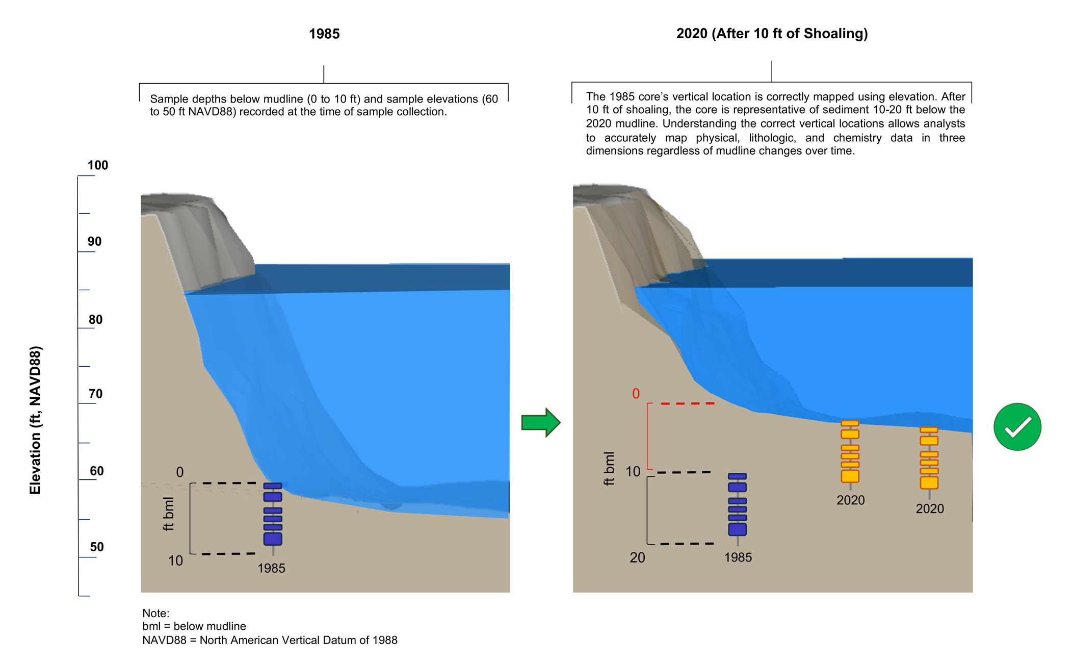
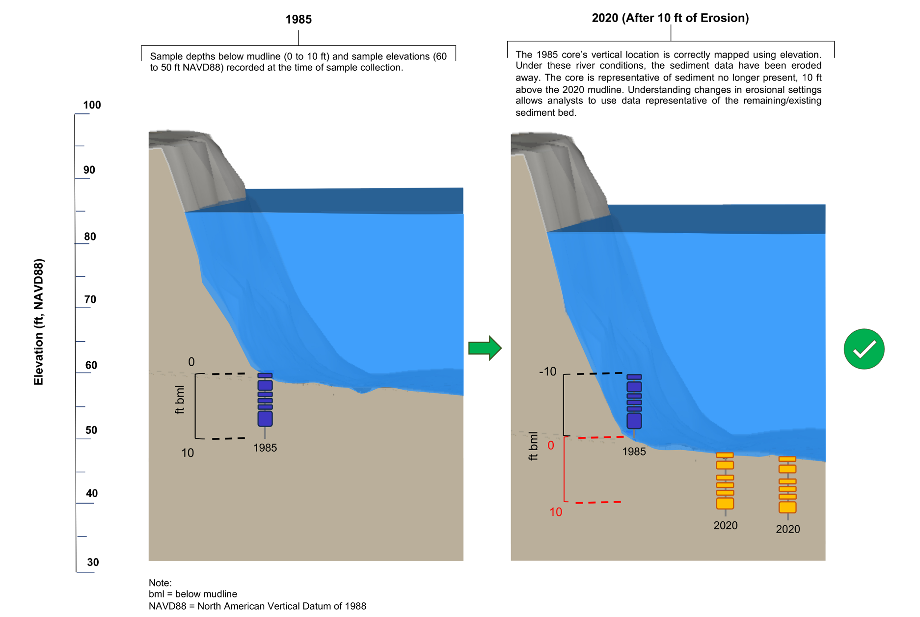
For subsurface sediment samples, finding the elevations of each sample interval requires subtracting the depth below mudline of the top and bottom of the sample interval from the elevation of the mudline at the sample location. Using elevation substantially reduces error and is preferred for analysis because it offers better vertical representation and puts both current and historical data in the same vertical datum. Understanding where the sediment represented by historical data lie within a current sediment bed would require a current-day bathymetric survey and a comparison of the elevations for each sample interval to the mudline elevation at the sample location. For example, a historical sample collected at -25 to -26 ft NAVD88 from a depositional location with a current mudline elevation of -22 ft NAVD88 would represent sediment 3 to 4 ft below that current mudline. An evaluation of current conditions should consider those data to represent the 3- to 4-ft interval of subsurface sediment, regardless of the depth below mudline from which the sample was originally collected years before. Figure 1b shows a correct representation of historical data in vertical space where a riverbed has shoaled. (Figures 2a and 2b illustrate erroneous and correct mapping of sample intervals, respectively, in an erosional location. This is also relevant in a dredged area, where the elevation of the sediment bed is lowered. Using sample elevations help one understand which data represent sediment that has been removed by dredging.)
Figure 1b. Correct mapping of historical data in a depositional setting
Figure 2a. Erroneous mapping of historical data in an erosional setting
Figure 2b. Correct mapping of historical data in an erosional setting
Conclusion
Rivers, waterways, canals, lakes, and bays can be complex and dynamic systems, often with long histories of modifications to their shorelines and to the seafloor, and it can be challenging to understand spatial and temporal changes. Fortunately, in instances where a sediment system has been studied extensively, various historical bathymetry, chemistry, and lithology data are available to build a robust elevation-based CSM. Three-dimensional modeling software is one of the most powerful tools for combining and viewing these data in a CSM. Seequent’s Leapfrog® Works is 3 dimensional modeling software that has many data analysis capabilities, including a suite of interpolation features that allows for the numeric modeling/interpolation of 2 dimensional surfaces (e.g., depth of contamination) and 3 dimensional volumes (e.g., dredge prisms, contaminant footprints).³ The modeling software also allows users to “hang” historical data using the elevation data on the current mudline so that the data lie accurately in vertical space relative to more contemporary data. Determination and use of sample elevations accurately accounts for changes in riverbed/ seafloor morphology, precisely places chemical and lithologic data in vertical space, and produces a more accurate CSM for risk management, remedial design, and other decision-making. As a project progresses, an elevation-based dataset allows analysts and engineers to continually evolve relevant evaluations and designs to reflect current conditions as they change. This is particularly important in sediment megasites where decades of data collected over several phases, leading up to and following a Record of Decision, may be used to design a remedy and to evaluate effectiveness.
Glossary
Depth—The vertical distance from a reference point (e.g., the sediment surface, also referred to as mudline, at the time of sample collection) to another point. Depth is a relative measurement for which the reference point must be defined because in a dynamic sediment system the reference point’s (the mudline’s) vertical location (i.e., elevation) changes. Assuming that a reference point such as the mudline surface is fixed over time may lead to inaccurate interpolations.
Elevation—The height above or below a fixed reference datum. Elevation is a static measurement useful for accurately recording a sample’s vertical location in a manner independent of whether the sediment bed shoals or erodes. Common datums include the North American Vertical Datum of 1988 (NAVD88) and National Geodetic Vertical Datum of 1929 (NGVD29).
Mudline—The surface of the sediment bed, also referred to as the riverbed or the seafloor. In dynamic water bodies, the mudline can change over time through shoaling or erosion.
Vertical Datum—A geodetic model with a unique and static (fixed over time) zero point. Several regional and local vertical datums are typically relevant in a particular study area, such as NAVD88 (regional current), NGVD29 (regional historical), the Columbia River Datum (local), and tidal datums (local and specific to a particular coastline, bay, or tidally influenced river). So the vertical datum used must be clearly defined when vertical locations are recorded.
¹ In this article “mudline” refers to the top of the riverbed or the seafloor; the interface between the sediment and the water column.
² The length of time it takes for surface sediment to be eroded or buried depends on many factors, including but not limited to, water body size, currents, tidal exchange, anthropogenic activities, flood events, and sediment loads from upstream and lateral inputs. However, in general, it takes years to decades for entire surface sediment intervals to change, either through burial (deposition, shoaling) or erosion.
³ https://www.seequent.com/products-solutions/leapfrog-works/


