Floating Offshore Wind: Overcoming Seafloor Challenges
By Nathan Rebuck, Ph.D., Senior Scientist
Daniel Doolittle, Principal, Offshore Wind
Craig A. Jones, Ph.D., Managing Principal, Business Director - Marine, Coastal, Climate, and Technology Services
Diane Achman, Senior Scientist
As the world continues the path of decarbonization and renewable energy transformation, the need for additional offshore wind facilities to meet the energy requirements of climate goals has become apparent. Recent lease sales in the waters of the United States by the Bureau of Ocean Energy Management have generated increased domestic interest in resolving the engineering and environmental issues related to both fixed bottom and floating wind power production facilities.
Floating Offshore Wind
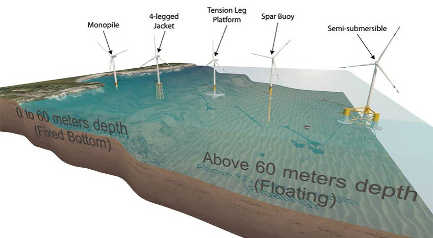
Almost all commercial-scale offshore wind turbines to date are installed on foundations fixed to the seafloor in relatively shallow waters (<60 meters). While these facilities have trusted engineering solutions to surviving the rigors of the offshore environment, novel solutions will be required to access the much more expansive deepwater areas. Floating offshore wind projects, like those proposed along the deeper waters of the Pacific and Atlantic coasts, are in active development at present. Deepwater floating offshore wind technology involves wind turbine generators mounted on floating structures that are tethered or anchored in deep waters, typically farther from shore than traditional fixed bottom offshore wind farms. This floating technology enables the harnessing of significant wind energy resources where conventional structures cannot be installed directly into the ocean floor. Electrical cabling is used to transmit the generated power from the turbines to an offshore or onshore substation, ensuring continuous energy transfer. Where the windfarm foundations and transmission cables interact with the seabed, a series of engineering and environmental challenges arises.
Figure 1. Offshore wind foundation installation methodology is determined by local substrates and geology. Fixed platforms are generally used in shallower waters (<60 meters of water), whereas deeper waters require floating solutions. https://www.nrel.gov/news/ program/2020/images/115749-bauer-848.jpg
Subsea Cabling
In large-scale commercial windfarms, energy from each individual turbine is consolidated via a system of array cables at an offshore substation. The electrical current is typically increased in voltage to reduce transmission loss prior to being transferred from the substation to a landfall and an onshore grid interconnection. These export cables can transit tens or hundreds of kilometers and are typically buried under the seafloor.
On the continental shelf, in-water trenching technologies can be used to bury the cables for protection. Installation via these trenching tools works well in soft sediments and can be run directly to the shoreline in some environments. However, it is an inappropriate method for installation in hard or rocky bottoms, or in areas of steep bathymetry. In these areas, cables may be laid on exposed seafloor and subsequently covered or armored with some form of protection or brought to shore using horizontal directional drilling. In regions where cables are trenched or exposed on the seafloor, hazards are identified through traditional geophysical data including multibeam sonar and subbottom profilers. As water depth increases, the resolution of geophysical data decreases, leading to increased uncertainty in seafloor conditions for both engineering and environmental assessment needs. Integral’s scientists and engineers address this uncertainty in environmental assessment by utilizing additional technologies to identify, avoid, and mitigate these hazards.
Finding, and Avoiding, Sensitive Benthic Habitats
Offshore benthic habitats are of immense ecological value, hosting diverse marine life and playing a crucial role in the ocean’s health. The habitats, made up of varying geoforms, substrate, and biota, can act as crucial breeding and feeding grounds, maintain biodiversity, and contribute to nutrient cycling. However, the installation of offshore infrastructure, such as cabling, can potentially harm these habitats. Potential stressors include physical disturbance from installation activities, alteration of local hydrodynamics, noise, and electromagnetic field emissions.
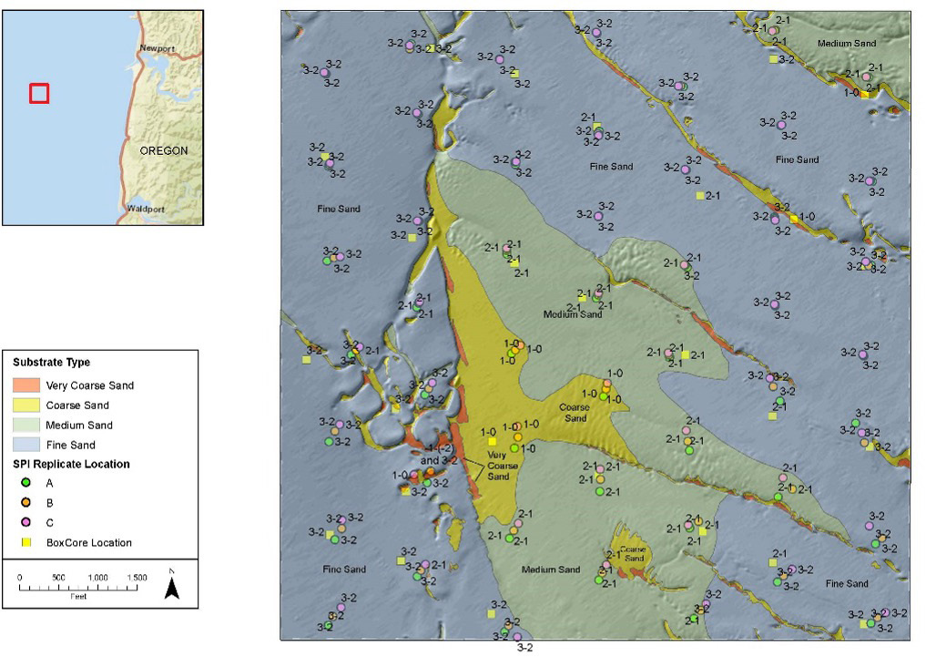
Integral worked with the U.S. Department of Energy, Oregon State University, and other collaborators at the PacWave South energy test site offshore of Newport, Oregon, to develop a consistent and semiautomated method for seafloor surveying by using a combination of traditional geophysical methods (multibeam echosounder) and sediment profile and plan view (SPI–PV) imagery. These studies better characterize benthic habitats in deep waters (Figure 2). The high-resolution benthic habitat maps below prove invaluable for environmental assessments and monitoring of offshore energy sites (Figure 3). Overall, the development of an image processing platform that automatically measures key features represents a step forward in the ability to avoid potentially damaging impacts to sensitive habitats and communities during windfarm construction.
Figure 2. Map generated from Integral’s combined multibeam echosounder and SPI–PV mapping efforts (Revelas et al. 2020) that supported the new shrimp population discoveries in Henkel et al. (2022). The mapping illustrates the classification of four distinct CMECS geoforms, potentially indicating areas of sensitive habitat and ecological importance.
Integral has conducted 22 SPI–PV surveys for offshore wind developers on the U.S. east coast. The resulting highly resolved seafloor habitat maps have allowed developers to design windfarms and cable routes in an environmentally sensitive manner, and have allowed regulators to verify compliance with existing protective measures. Our experience conducting SPI–PV surveys in deepwater habitats, combined with our expertise in data analysis necessary to offshore wind developers, uniquely places Integral in a position to be at the forefront of benthic assessments for floating wind installations.
Protection from Geohazards
Floating offshore wind projects also face a range of geohazards due to the unique geological and oceanographic conditions in deeper waters. For example, the California offshore wind lease areas are characterized by a complex and varied seafloor topography, including steep submarine slopes and canyons, which can lead to geotechnical challenges such as slope instability and underwater landslides. Careful geotechnical and geological assessments are crucial for site selection and design of offshore wind installations in this region to ensure their resilience against these geohazards.
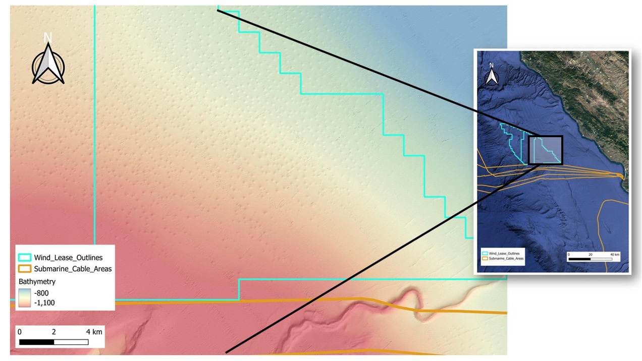
An example of unique features off Morro Bay are distinctive pockmarks on the seafloor. These pockmarks are essentially craters or depressions on the seabed, varying in size and shape that could pose a challenge for cabling and anchoring of offshore wind turbines. A joint study led by BOEM (2021) used high-resolution geophysical and geological surveys to analyze seafloor and shallow subsurface geology, including fault structure, sedimentary turbidity flows, and active fluid flow in the region (Figure 3). Fortunately, the study found little to no evidence for recent fluid or gas advection in the pockmark field, hazards that could introduce significant risk to seafloor infrastructure. However, evidence of sediment transport and sediment flows in the region need further investigation to minimize and mitigate these potential risks. Similar hazards may exist at other wind development sites yet to be surveyed. Integral’s benthic analysis and geohazard identification capabilities will inform marine planning, improve understanding of shallow geologic hazards and sedimentary processes, and better inform future offshore development activities.
Figure 3. Map of the three offshore wind leases along the central coast of California in approximately 1000 m of water. The zoom shows multibeam bathymetry which illustrates pockmarks that were observed in the surveys (BOEM 2021).
The installation of floating wind turbines has the potential to contribute a significant percentage of global renewable energy goals. Doing so in a manner that both protects vital energy infrastructure and minimizes harm to existing habitats and migratory species will require advanced technologies and techniques. Integral provides leading expertise in addressing complex seafloor challenges within the offshore wind industry through a blend of innovative and comprehensive approaches. Our expertise encompasses a broad range of services essential for evaluating seafloor conditions to identify potential hazards, locate sensitive habitats, and minimize risk to both assets and the environment.
Integral is using advanced techniques like multispectral multibeam mapping and SPI–PV imagery, which facilitate the development of highly resolved seafloor maps. Since 2019, Integral has been supporting numerous offshore wind clients with benthic and essential fish habitat mapping services that are underpinned by delivery of SPI–PV imagery and detailed image analysis and reporting/ mapping products. These habitat insights are provided to regulators and stakeholders during the permitting and site characterization phase of the offshore wind farm development process. To date, Integral scientists have conducted nearly two dozen SPI–PV surveys for the U.S. offshore wind industry, and Integral is uniquely suited to launch SPI–PV surveys in deeper sites where floating offshore wind platforms are planned.
Integral’s services extend to metocean assessments, acoustics, and electromagnetic field assessments; and pioneering automated image analysis tools for seafloor imagery further underscore our capability in delivering quality-controlled data that adhere to regulatory standards. Our holistic and technical approach, combined with a commitment to environmental sustainability, positions Integral at the forefront of solving complex seafloor problems in the constantly developing offshore wind sector.
References
BOEM. 2021. California deepwater investigations and groundtruthing (Cal DIG). Volume 2: Fault and shallow geohazard analysis offshore Morro Bay. OCS Study BOEM 2021-044. U.S. Department of the Interior, Bureau of Ocean Energy Management, Pacific OCS Region. November.
Henkel, S.K., Revelas, E.C., Wodzicki, S., and Chapman, J. 2022. Discovery of a large offshore population of the northeast Pacific burrowing shrimp Neotrypaea sp.(Decapoda: Axiidea). Estuarine, Coastal and Shelf Science. doi.org/10.1016/j.ecss.2022.107936
Revelas, E.C., Sackmann, B.S., Maher, N.M., and Jones, C.A. 2020. Mapping of benthic habitats at marine renewable energy sites using multibeam echosounder and sediment profile imaging technologies. Offshore Technology Conference. Houston, Texas. May. doi.org/10.4043/30733-MS


