Dredged Material Management Sampling: Considerations for Maintenance Dredging at a Yacht Club on the Lower Duwamish Waterway
By Olivia Hargrave, P.E., Senior Engineer
When dredging is part of a remediation or maintenance project, managing the dredged material can be expensive and time-consuming. The primary influence on dredging costs is disposal; in-water disposal of dredged material at open-water disposal sites in Washington’s Puget Sound is currently $0.75 per cubic yard, which doesn’t include the cost of dredging or transportation. By contrast, upland disposal tipping fees at a local nonhazardous landfill can be orders of magnitude greater. So, even if only a portion of the dredged material can be disposed in-water, the potential for reduced project costs is worth evaluating. Chemical constituents in the dredged material should be evaluated early and thoroughly within the project lifecycle.
Characterizing the material to be disposed in open water is a highly regulated process that is dependent upon site history, existing data, hydrodynamic forces, and budget. Dredged material management is typically regulated by a collection of stakeholders. In Washington, disposal decisions are issued by the Dredged Material Management Program (DMMP), which is cooperatively managed by the U.S. Army Corps of Engineers, Seattle District; the U.S. Environmental Protection Agency, Region 10; the Washington State Department of Ecology (Ecology); and the Washington State Department of Natural Resources.
Integral’s recent dredged material characterization for the Duwamish Yacht Club (DYC), to support an upcoming maintenance dredging project, provides our case study for the universal challenges of sampling during the management of dredged material. The DYC is a small yacht club in the upper reach of the Lower Duwamish Waterway (LDW), a Superfund site in Seattle, Washington. This article describes the key considerations for dredged material management projects, in general, and uses illustrative examples from the DYC for emphasis.
Dredged Material Context
The first step in characterizing dredged material for its suitability for open-water disposal is to review local (DYC in this example) and surrounding (upper reach of LDW) area history and context. Compiling relevant history includes conducting interviews with knowledgeable persons; reviewing documents, particularly permits; and gathering existing data. These reviews can yield information indicating the potential (or lack thereof) for historical or ongoing contamination of the sediment to be dredged. Context includes ongoing in-water and upland uses and adjacent parcel activities.
At the DYC, dioxin/furan concentrations were of particular concern. In Puget Sound, material to be dredged is tested for dioxins/furans on a case-by-case basis if there is a reason to believe these chemicals may be present, such as proximity to historical sources or existing data showing elevated levels of dioxins/furans. Ecology’s Environmental Information Management System (EIMS) contains past DMMP study data, which is used to determine the presence/absence of contaminants in the sediment and point to potential sources. The LDW data sets are also in EIMS, and where these data overlap the planned dredge prism laterally and vertically can provide context about the expected condition of the material to be dredged. The LDW data set is primarily from samples collected less than 2 feet below the sediment surface. Depending on the planned dredge depth and any previous dredging events, existing data may have limited use in developing an understanding of the material to be dredged.
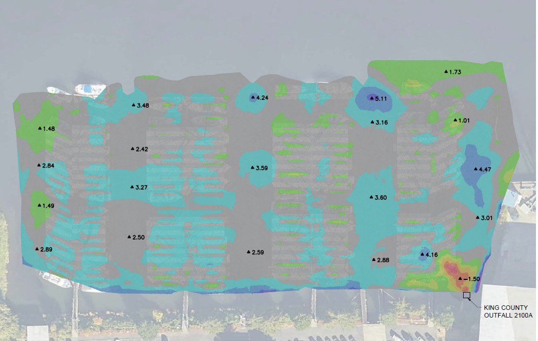
The second step is to combine the known site information with the hydrodynamic information. A recent bathymetric survey of the area to be dredged is critical for calculating the volume of sediment for disposal. In addition, when compared to previously collected bathymetric data, the rate of erosion and/ or accretion can be determined. If dredging is to take place months or years after the data collection, the rate of deposition needs to be factored into the sampling design. At the DYC, Integral compared two bathymetric surveys collected 12 years apart to visualize the magnitudes of sediment accumulation and erosion over the past decade. Sufficient timing between bathymetric surveys ensures that a comprehensive understanding of sedimentation rates is gained and that episodic events are not unduly affecting the findings.
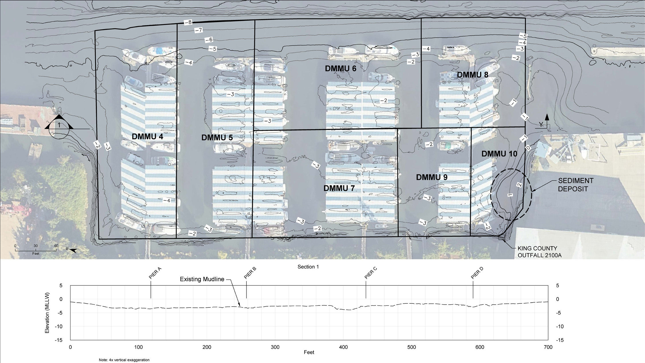
The 2011 and 2023 bathymetry surveys, along with a knowledge of DYC history, context, and operations, were used to subdivide the DYC’s planned dredged material into dredged material management units (DMMUs). The sediment affected by an ongoing source was delineated in a separate unit from the rest of the planned dredge area. The bathymetric survey data was the basis for developing a map that showed the change in sediment elevations between 2011 and 2023, which revealed how shoaling near a stormwater outfall of interest had shifted over 12 years, allowing us to draw a DMMU around the area that had been influenced by the outfall since the previous maintenance dredging 24 years ago (DMMU 10 in Figure 1).
Figure 1. A bathymetric survey revealed an area of sediment deposition near an outfall. DMMU 10 was delineated around the sediment deposit.
Understanding erosion and deposition rates is also crucial to interpreting historical site data. For example, at the DYC, 2013 data from a previous dredged material characterization study is from sediment that has since been buried under an additional 3 feet of accumulated sediment (Figure 2). The bathymetry survey, characterization, and elevation data from a previous disposal study, and knowledge of the DYC’s limited sources, meant that in some areas of the yacht club, only the newly deposited 3 feet of sediment needed to be characterized for disposal. The underlying material was adequately characterized by the previous 2013 investigation. This reduced the project complexity at an early stage. Using sample elevations to assess site data is discussed in more detail in the Benthic Zone article by Tufano, Kirkland, and Uselman (2023) titled “Using Accurate Sample Elevations to Characterize Sediment Conditions with 3-Dimensional Modeling.”
These data are key to preparing a simple, yet comprehensive, dredged material characterization plan because they reduce uncertainty in the three dimensions of the dredge prism. The dredge prism must be subsectioned into DMMUs that enclose a deliberate portion of the area to be characterized and later dredged in manageable units. The vertical dimension, which includes the z-layer (the leave surface following the planned dredging) is the most difficult of the dimensions to properly characterize, because, due to hydrodynamic forces and the precision of the planned dredging, it is temporally dynamic.
Informed Decisions
Once the subdivision strategy is determined, the sampling and analysis plan is developed in accordance with agency guidance. It is important to engage with the regulatory stakeholders early in the process, to get their input on the sampling strategy. Regulators will approach the project with a wealth of relevant past project knowledge and be able to identify stumbling blocks early on. For example, total chlordanes, a persistent pesticide, had been observed historically in DYC sediment. The Puget Sound DMMP screening level for total chlordanes is sometimes lower than the practical quantitation limit (PQL) using standard analytical methods, which can result in detections of total chlordanes that are below the detection limit but that exceed the DMMP screening level, also referred to as nondetect exceedances (NDEs). Although analytical laboratories in Washington are working toward reducing the PQLs for multiple compounds, including chlordanes, a notable frequency of sample results in dredged material management studies were NDEs. Knowing this and the potential for chlordanes to be present at the DYC, the DYC project used a high-resolution pesticide method to ensure there were no NDEs. The minor increase in the upfront cost for the high-resolution method saved time and reduced the potential for delays. The regulator’s knowledge of the analytical limitations with total chlordanes was valuable to the project.
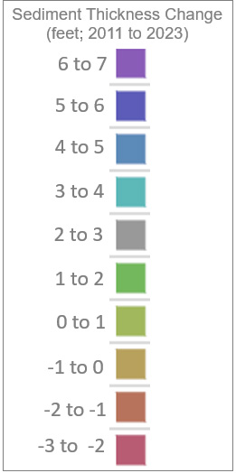
Figure 2. A difference map comparing 2023 to 2011 sediment elevations shows erosion northeast of the outfall. This indicates that the outfall’s influence of the sediment is dynamic and has extended further northwest than the sediment deposit in 2023 alone reveals.
If chemical results were to result in the rejection of a DMMU for open-water disposal, the use of bioaccumulation testing and bioassays is an optional tool to continue the open-water disposal consideration (vs. upland disposal). These tests evaluate the potential ecological impacts of open-water disposal of dredged sediment directly. Bioassay testing measures the chronic and acute toxicity of sediment to benthic organisms. Bioaccumulation tests measure the degree to which sediment causes contaminants to bioaccumulate in benthic species (e.g., bivalves, polychaete worms). Biological testing can override chemistry results, allowing DMMUs that fail the chemistry criteria to still be considered suitable for open-water disposal. The types of chemicals and degree of contamination can influence the decision whether to pursue biological testing or to dispose the material in an upland location.
The advantage to pursuing biological testing is the potential for reduced disposal costs if materials pass such tests, and thus allow failing chemistry results to be overridden. The disadvantages are greater study costs and an extended schedule, as well as no guarantee of a desired outcome. The laboratory costs for biological testing are greater than those for chemical analysis.
Biological testing also requires longer field collection times than those for chemistry testing, due to the greater volume of sediment required. If biological testing is used, it is important to track the volume of sediment as cores are collected in the field. To minimize backtracking during sample collection, field staff should carefully record the volumes collected in each core in real time, factoring in recovery. If additional volume is needed, additional cores can be added to the field effort as it progresses, instead of during an additional sampling equipment and personnel mobilization. Well-prepared field staff make a difference when collecting biological and chemical samples in one mobilization.
Finally, biological analyses take time. Biological testing cannot be started until preliminary chemical data are obtained. Bioaccumulation tests take the longest time of the biological tests at 45 days, with additional time needed for testing the resulting tissues. For those who are prioritizing rapid dredging over potential cost savings, biological testing would not be practical.
Conclusion
Dredged material management sampling is a process that has the potential to lower dredged disposal costs and simplify construction projects. In summary:
- The project’s data gaps, costs, and benefits associated with dredged material management should be considered early.
- Reducing site unknowns can start with a review of site history and existing data, and an understanding of the hydrodynamics can inform the plan for dredge characterization sampling.
- Engaging with regulatory agencies early and often can lead to reduced uncertainties.
- Biological testing is a good option for many sites, where upfront investment in testing reduces later project costs.
- Finally, field data collection should emphasize planning and field staff flexibility.
¹WAC 332-30-166
²Tufano, B., K. Kirkland, and L. Uselman. 2023. Using accurate sample elevations to characterize sediment conditions with 3-dimensional modeling. The Benthic Zone, Integral Consulting Inc., Denver, CO. September.
³DMMP. 2020. Follow-up to the 2011 DMMP Clarification paper, Marine Sediment Quality Screening Levels: Adopting RSET Marine SLs for Use in DMMP. https://www.nws.usace.army.mil/Missions/Civil-Works/Dredging/Program-Updates/


