Case Study
Arctic Coastal Erosion, Coastal Hazards Evaluation: Alaska
By Craig A. Jones, Ph.D., Managing Principal, Business Director - Marine, Coastal, Climate, and Technology Services
Christopher Flanary, Ph.D., Consultant
OUR CHALLENGE
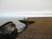
Permafrost along Alaska’s north slope comprises 34% of the world’s coastlines. Due to heightened wave activity and temperatures, erosion of the permafrost coastline around Drew Point can exceed 10 m/year and is increasing. Current tools for predicting coastal evolution were developed for temperate areas and noncohesive sediments, limiting their applicability for permafrost coastlines. To develop adaptation strategies for Arctic infrastructure, we need accurate methods of predicting these discrete events.
OUR APPROACH
We’ve teamed with Sandia National Laboratories, the U.S. Geological Survey, University of Alaska Fairbanks, and University of Texas at Austin to develop modeling and monitoring tools to accurately predict Arctic coastal erosion. The hydrodynamic components being developed for the modeling system will integrate oceanographic and terrestrial processes relevant to quantifying rates of permanent coastal land loss.
OUR IMPACT
Accurate prediction of Arctic coastal erosion rates will allow for better prediction of coastal hazards, thereby informing management decisions for communities and infrastructure that are built on the permafrost. These innovative tools can be applied to the assessment of coastal hazards worldwide in an effort to protect communities and infrastructure.
Published
May 23, 2019

Key Contact
Dr. Craig Jones serves as the managing principal for Integral’s Marine, Coastal, Climate, and Technology Services. With more than two... Full bio

Key Contact
Dr. Christopher Flanary is a physical oceanographer with more than 10 years of experience performing site assessments for government agencies... Full bio