
Integral Insights
Offshore Wind Development News: BOEM Site Assessment and Construction and Operations Phase
By Craig A. Jones, Ph.D., Managing Principal, Business Director - Marine, Coastal, Climate, and Technology Services
Damian V. Preziosi, Managing Principal, Strategic Initiatives Director
Lance W. Fontenot, Ph.D., PWS, Senior Consultant
Bureau of Ocean Energy Management (BOEM) Site Assessment, Construction, and Operations Plans
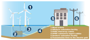
The Inflation Reduction Act provides a tremendous boost to offshore wind development and the upcoming leasing of wind energy areas in federal waters off California, the Gulf of Mexico, Oregon, and the Gulf of Maine. At Integral, we think it’s a good time to discuss the activities that happen after a developer is given the exclusive right from leasing to consider offshore wind development of a specific offshore area – the Site Assessment and Construction and Operations Plans – and how to get the most value from each of them.
Here’s a step-by-step walkthrough of the process:
Step 1: Site Assessment
After winning a lease, lessees have up to one year to engage BOEM, develop a suitable Site Assessment Plan (SAP), and begin the responsible, site-specific evaluation of baseline conditions for suitable engineering, design, and site layout of their potential wind farm. SAPs are prepared in accordance with 30 Code of Federal Regulations (CFR) §§ 585.606, 610, and 611, as well as the Guidelines for Information Requirements for a Renewable Energy SAP issued by BOEM (current version June 2019). Important conditions to be investigated include the following:
- Wind resource assessments to support site selection, yield optimization, array engineering, and financial investment decisions. Usually obtained via deployment of floating LiDAR systems, existing infrastructure in the Gulf of Mexico will offer an interesting “fixed” alternative to consider. Lessees should also consider a cost-benefit analysis of the deployment of additional instrumentation along with the wind resource assessment that offers longer-term, site-specific environmental and ecological information in “greenfield” areas that have less historical investigation and may have significant litigation risk.
- Geophysical and geotechnical investigations to evaluate seafloor conditions to support front-end engineering of foundations, identification of potential shallow hazards, sensitive habitats and archeological resources, and development of cable routing options. Lessees can consider multispectral multibeam mapping and Sediment Profile Imagery (SPI) to allow rapid development of quantitative seafloor maps that exceed industry standards for engineering, environmental, and ecological information. Integral has successfully conducted nine environment baseline SPI–PV surveys for multiple wind farm projects off the East Coast.
- Metocean assessments of wind, wave, currents, sediment transport and other oceanographic conditions to model interactions with proposed structures, cable armoring and scour protection. Integral performs cost-effective and streamlined approaches to project planning, data collection, analysis, and modeling for offshore wind projects, using long-term oceanographic databases, remotely sensed ocean data, commercially available databases, and both shallow and deep water measurement systems. Integral has worked with multiple regulatory agencies to use SEDFlume to provide an in-situ measure of seafloor stability and erodibility.
- Biological surveys to provide site-specific investigation of fisheries, benthic and other critical habitats, marine mammals and sea turtles that may be impacted by the project’s activities.
Step 2: Construction and Operations Plans
After the approval of the SAP, lessees have up to 5 years to develop a suitable Construction and Operations Plan (COP) and perform additional site characterization and site assessment activities before construction activities start. COPs are prepared in accordance with 30 CFR § 585.626, and BOEM has issued Information Guidelines for a Renewable Energy Construction Operations Plan (current version May 2020), further explaining the applicable provisions of BOEM’s renewable energy regulations.
The COP is a detailed plan for the construction, operations, and conceptual decommissioning plans for the lease, including onshore and support facilities and anticipated project easements. To develop a COP, surveys are required to inform the project’s design and provide information to comply with NEPA and other relevant laws. These key identifications include potential hazard information (meteorology, oceanography, sediment transport, geology, and shallow geological or manmade hazards), water quality, biological resources (including threatened and endangered species and sensitive resources and habitats), archaeological resources, social and economic resources, coastal and marine uses, consistency certification from the affected coastal state, and other resources, conditions, and activities identified by BOEM. Complete requirements of COP surveys are described in 30 CFR § 585.626 and Information Guidelines for a Renewable Energy Construction Operations Plan issued by BOEM in May 2020 (https://www.boem.gov/sites/default/files/documents/about-boem/COP%20Guidelines.pdf). In October 2022, BOEM proposed new guidance, known as the “NOI Checklist,” that identifies the minimum threshold for a partial COP submission that an applicant is expected to meet before BOEM will initiate the formal environmental and technical review process through publication of a NOI to prepare a NEPA document for the project (https://www.boem.gov/newsroom/notes-stakeholders/boem-seeks-public-comment-proposed-guidance-submission-offshore-wind). Moreover, BOEM will consider conformance with the NOI Checklist when considering acceptance of FAST-41 Initiation notices, where applicable. The public comment period for the draft guidance ended mid-December of 2022, and final issuance is expected soon.
Some examples of the specialized surveys required by BOEM during the site assessment and construction and operations phase are:
Metocean studies
Typically, meteorological buoys are deployed to measure and analyze winds, waves, ocean currents, sediment, and water quality properties. Metocean studies also involve numerical modeling of waves and currents and hydrographic and geophysical surveys.
Electric and Magnetic Field (EMF) Assessments
EMF assessments are completed for submarine cables conveying electricity in offshore and onshore areas associated with proposed developments. These assessments evaluate the potential for effects of EMFs on marine organisms, human health, and navigation.
Integral has extensive experience performing EMF assessments for offshore wind projects off the East Coast. Our scientists produce technically sound assessments to address the needs of BOEM and advance the state of the science with respect risk assessment use at the scales of the project and broader ecosystem.
Comprehensive Seafloor Characterization
Sediment profile and plan view imaging (SPI-PV) is a tool that provides ground truthing for geophysical and environmental surveys through rapid photographic image acquisition. A camera frame is lowered to the seafloor to acquire plane view and profile imagery of the sediment.
Integral has pioneered a data analysis tool that automates the image analysis from seafloor imagery. Automated image analysis provides rapid characterization of seafloor conditions and the quality-controlled data required by BOEM’s regulations for benthic habitat assessment.
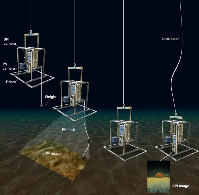
Sediment profile and plan view imaging (SPI-PV) of the seafloor.
Another tool unique to Integral’s toolbox is the SEDFlume, which provides a method for measuring sediment erosion that garners site-specific data on sediment erosion and the stability required for site characterization. The SEDFlume methodology has been approved for use by multiple regulatory agencies at sites across the globe.
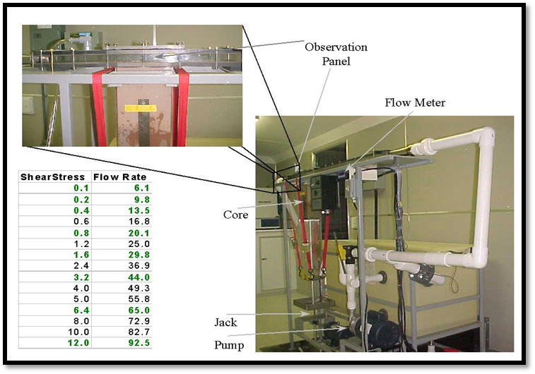
The SEDFlume method measures sediment erosion for site characterization.
Integrating geophysical data, enhanced multibeam, and ground truth imagery substantially increases the rate and quality of quantitative foundation and cable route characterization. Integral has successfully conducted nine environment baseline SPI–PV surveys for multiple wind farm projects off the East Coast.
Acoustic Assessment and Monitoring
Marine noise is a key consideration for offshore operations. To minimize potential impacts of underwater noise on marine fauna, management plans are designed to comply with guidelines developed by the International Union for Conservation of Nature, the Joint Nature Conservation Committee, and the U.S. Marine Mammal Protection Act.
Integral scientists and engineers have extensive experience using acoustic monitoring to measure noise in the ocean, listen to marine animal activity, track animals acoustically, and model sound propagation. We deploy sophisticated acoustic equipment and apply robust risk assessment and management principles to marine mammal acoustic data analysis and synthesis.

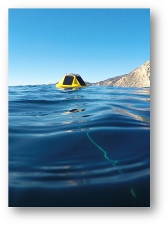
Acoustic monitoring is used in seafloor characterization.
In support of environmental monitoring technologies to evaluate the potential impact of marine renewable energy devices, Integral developed the NoiseSpotter® real-time passive acoustic monitoring system.
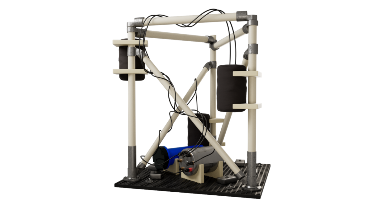
Integral’s NoiseSpotter® tool for acoustic monitoring of the ocean.
Traditional hydrophone arrays measure only acoustic pressure, necessitating the need for a large number of hydrophones to achieve accurate source location estimation. The NoiseSpotter® array of acoustic particle motion sensors measures three-dimensional acoustic particle velocity in addition to acoustic pressure. The NoiseSpotter® measures continuous noise to better study sources of sound that have the potential to alter marine mammal or fish behavior.
Published
December 8, 2022

Key Contact
Dr. Craig Jones serves as the managing principal for Integral’s Marine, Coastal, Climate, and Technology Services. With more than two... Full bio

Key Contact
Mr. Damian V. Preziosi is an environmental scientist and risk assessor with more than 25 years of experience in evaluating... Full bio