Modeling & Data Visualization
Clarity and confidence needed for informed decision-making when data complexity threatens project success.
Understanding natural systems through holistic data sets make it easier to extract insights or communicate findings to regulators, stakeholders, and decision-makers. Integral transforms this challenge by combining advanced environmental modeling with purpose-built visualizations that turn site-specific complexity into clear actionable intelligence for industrial companies, municipalities, and litigation teams.
Featured Projects
Groundwater Flow and Transport Model of Pentachlorophenol Plume Attenuation in Oregon
Alaska LNG Sediment Modeling
Groundwater Modeling and Impact Assessment for Large-Scale Lithium Brine Operations in Northwestern Argentina
Resources
Using Three-Dimensional Modeling to Optimize Investigation and Remedial Injection Programs at CVOC-Contaminated Sites
Ongoing Use of Fate and Transport Modeling to Support a Successful Natural Attenuation Remedy for PCP in Groundwater: A 10-Year Perspective
Sediment and PCB Transport in San Leandro Bay
Technical Leaders
Mandy Tulich, P.G. Senior Consultant, Practice Director - Hydrology, Geosciences, and Chemistry
Grace Chang, Ph.D. Senior Science Advisor, Director of Research and Development
Michael Sweetenham, P.G. Senior Consultant
Samuel McWilliams, E.I.T. Senior Consultant, Practice Director - Marine Science and Engineering
Kara R. Scheu, Ph.D. Senior Consultant
Christopher Flanary, Ph.D. Consultant
Stephen Sherman, P.G. Consultant
Brandon C. Tufano Consultant
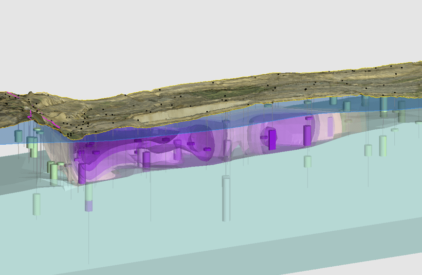
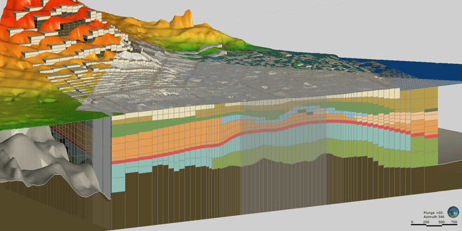
Geologic Modeling
Advanced geological characterization and 3-dimensional modeling to understand subsurface conditions, structural geology, and site-specific hydrogeologic settings. Our geologic modeling creates a strong foundation for environmental investigations, remediation design, and regulatory compliance through integrated geospatial analysis and visualization.
- Spatial data frameworks illustrating existing data extent within site areas and identifying data gaps for adaptive sampling plans and remedial design planning
- Enhanced site characterization utilizing lithologic, hydrologic, and other information to understand site conditions and track remedial progress
- Spatial evaluation and interpolation of soil, sediment, surface water, pore water, and groundwater contaminant data
- Effective communication tools and visual aids for remedial planning, implementation, and stakeholder engagement
Contaminant Fate and Transport Modeling
We conduct quantitative analyses resolving magnitude, sources, fate, and transport of organic and inorganic chemicals in environmental media, developing robust conceptual site models that describe physical, chemical, and biological processes governing contaminant behavior. Our fate and transport modeling supports more effective site investigations and remediation strategies.
- Source characterization with analytical and numerical modeling tools to evaluate flow and transport
- 1-, 2-, or 3-dimensional modeling of organic and inorganic constituents through variably saturated soil and groundwater incorporating relevant partitioning, decay, and transformation mechanisms
- Prediction and assessment of remedial design effectiveness and re-contamination risk
- Multidimensional visualizations communicating model results to stakeholders

Groundwater Modeling
We provide comprehensive analytical and numerical modeling solving complex hydrogeological and geochemical problems, projecting subsurface flow and chemical transport, characterizing historical flow paths, delineating plumes, and predicting future contaminant movement. Our groundwater modeling uses robust platforms for multidimensional analysis in remediation and litigation settings.
- Sound hydrogeologic conceptual model development supporting defensible model frameworks
- Aquifer test design and analysis to estimate and constrain model input parameters within realistic site-specific ranges
- 1-, 2-, or 3-dimensional analytical and numerical modeling tools evaluating variably saturated flow and transport incorporating relevant decay and transformation mechanisms
- Model sensitivity and uncertainty evaluation supporting conceptual site models, site characterization needs, water resources planning, and remedial evaluations
- Multidimensional visualizations including simulated potentiometric surface contours, drawdown, particle traces, capture zones, and contaminant plumes
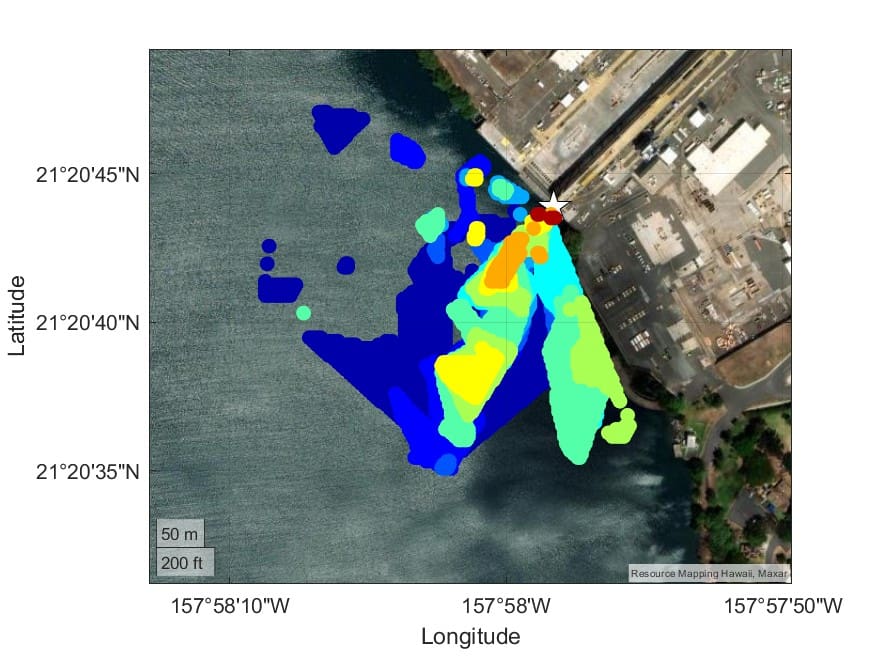
Sediment Modeling
We conduct specialized sediment transport and fate modeling using state-of-the-art platforms including DELFT3D, SWAN, and XBeach to evaluate hydrodynamic conditions, morphodynamic processes, and sediment behavior. Our sediment modeling supports navigation projects and environmental assessments in rivers, lakes, estuaries and the coast.
- Characterization of sediment and contaminant transport processes including riverine, tidal, and wave-driven contributions from outfalls and upstream sources
- Evaluation of sediment bed and remedy erosion potential, stability assessment, and natural recovery potential of impacted sediments
- Source characterization and transport supporting allocation and source control efforts
- Long-term performance prediction for caps and assessment of dredged area shoaling or scour potential

Stormwater Modeling
We provide surface water flow prediction and stormwater system analysis supporting water quality studies, NPDES compliance, allocation studies, site characterization, and remedial design. Our stormwater modeling uses integrated approaches that optimize system performance while meeting regulatory requirements and project objectives.
- Evaluation of stormwater drainage before and after site improvements
- Runoff determination during specific rainfall events
- Impact reduction of stormwater flow through contaminated site areas
- Comprehensive stormwater system analysis using software including HydroCAD
FAQs
Data visualization represents data in 2-dimensional and 3-dimensional space to help individuals and organizations understand the spatial extent and distribution of information pertaining to their sites. It makes complex information accessible, usable, and easier to discuss with stakeholders.
Integral takes a comprehensive approach to modeling, working with partners to ensure the model’s purpose is clear from the outset and considering all relevant factors that may influence outcomes. We complete models efficiently to meet goals while addressing uncertainties through rigorous quality assurance processes.
Data verification is an important first step of any model. Data sets go through quality assurance processes to remove potential errors, and visual quality assurance steps ensure data set accuracy. All visualizations are reviewed for errors, clarity, and conciseness before delivery.
Models represent and visualize complex environmental data in simplified, clear ways to support site understanding, decision-making, and communication. They transform technical complexity into actionable intelligence for both technical and non–technical audiences. Models also provide a means to characterize future or past conditions not represented by present-day data.
Integral has a proven track record of processing complex information and presenting data clearly to technical and non–technical audiences alike. Each model is designed with purpose and user in mind, data presentation is simplified to its essence, and graphics maintain clarity throughout the review process.