
Guam Wave Resource Assessment
Project Summary
Integral completed a pre-feasibility wave energy resource assessment for Guam, funded by request of Bluewater Network LLC (BWN) through the Pacific Ocean Energy Trust’s TEAMER program, to characterize the island’s nearshore and regional wave energy potential. Guam relies heavily on imported fossil fuels, making the identification of viable renewable energy resources a strategic priority for both energy security and climate resilience. The software tool Integral built to conduct the assessment provides a technical foundation to inform policymakers, developers, and stakeholders evaluating wave energy applications along Guam’s coastal waters and in other coastal regions of the world.
Location: Guam
Key Personnel
Christopher Flanary, Ph.D. Consultant
Samuel McWilliams, E.I.T. Senior Consultant, Practice Director - Marine Science and Engineering
Challenge
Guam’s dependence on imported fossil fuels created an urgent need for credible, site-specific data on the island’s wave energy resource.
Guam faces persistent energy security and climate resilience challenges magnified by its near-total reliance on imported fossil fuels. To evaluate whether wave energy could contribute meaningfully to a diversified renewable energy portfolio, decision-makers needed reliable, high-resolution wave resource data specific to Guam’s coastal environment.
Our Role
Integral led a comprehensive, multi-scale wave resource characterization using advanced modeling tools and established international standards.
Integral conducted the full scope of the wave resource assessment, beginning with a requirements analysis provided by BWN which led to a desktop review and synthesis of publicly available datasets—including bathymetry, coastal infrastructure, marine restricted areas, wave buoy measurements, and hindcast records—compiled into a geodatabase for spatial evaluation. Integral then applied its proprietary Site Energy Assessment and Monitoring Dashboard (SEAMOD) alongside 30-year WaveWatch III hindcasts to characterize large-scale wave climate patterns suitable for early-stage project screening. The team advanced to high-resolution, site-specific simulations using SWAN, incorporating refined local bathymetry and boundary conditions to capture nearshore wave transformation processes. Wave resource statistics were computed in accordance with IEC TC114 technical specifications.
What We Delivered & Results
The assessment produced spatially resolved wave resource data and identified the eastern coast of Guam as the most promising area for future wave energy development.
Integral delivered a layered wave resource characterization covering both regional patterns and high-resolution nearshore conditions. Key outputs included:
- A geodatabase synthesizing environmental, infrastructure, and oceanographic datasets for spatial site screening
- Regional wave climate analysis using SEAMOD and 30-year WaveWatch III hindcasts
- High-resolution SWAN model simulations capturing nearshore wave transformation around the full island
- Wave resource statistics including significant wave height, energy period, omni-directional wave power, and annual energy production (AEP), computed per IEC TC114 methodology
Preliminary SWAN modeling results identified spatial variability in wave power density around the island, with the eastern coastline showing the most promising conditions for early-stage technology evaluation. Monthly analysis of the northeast shoreline revealed higher wave energy during winter months, driven by stronger northeasterly tradewind swell and mixed-sea conditions. These findings provide a technical basis for identifying viable locations for future wave energy development and lay the groundwork for more detailed, site-specific investigations.
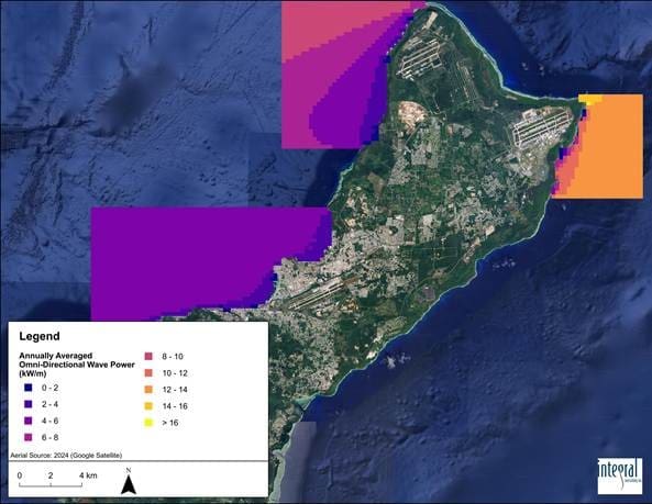
Figure 1. Annually Averaged Omni-Directional Wave Power for Three SWAN Domains around Guam
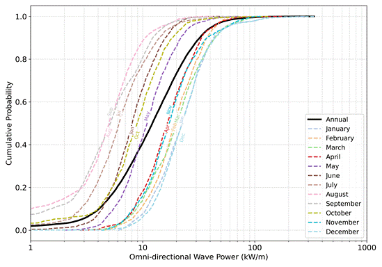
Figure 2. Cumulative Probability of Omni-Directional Wave Power by Month for Nearshore Guam along the Northeast Region