Forensic Wetland Delineation Resolves Regulatory Uncertainty at California Vineyard
Project Summary
Accurate assessment of site conditions prevents mischaracterization and informs cost-effective restoration.
Unauthorized disturbance along an intermittent creek at a California vineyard triggered violation notices from multiple agencies. Post-disturbance conditions—including seasonal ponding in disturbed areas—created uncertainty about wetland jurisdiction and restoration requirements. The vineyard owner needed definitive answers to satisfy regulatory obligations and avoid unnecessary costs.
Location: California
Key Personnel
Sadie McGarvey Senior Consultant – Practice Director, Permitting and Planning
Cristal Reagh Project Scientist
Challenge
Post-disturbance ponding created regulatory uncertainty about wetland jurisdiction and restoration scope.
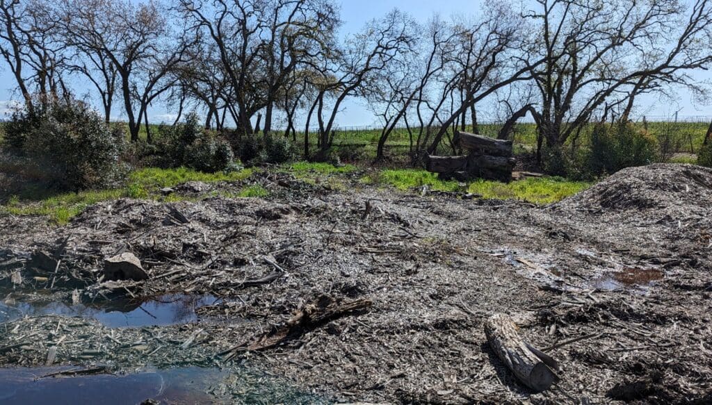
The site—a eucalyptus grove with poison oak understory—had been disturbed through unauthorized riparian work. A 2020 third-party assessment identified no wetlands, determining the creek was the only aquatic resource. However, after disturbance, woodchips and seasonal ponding appeared in two low-lying areas, presenting conditions that could indicate wetland presence.
The vineyard faced three critical questions:
- Was the ponding evidence of pre-existing wetlands that had been impacted?
- Would restoration need to address wetland mitigation in addition to riparian restoration?
- What were the actual baseline conditions before disturbance occurred?
Our Role
Integral conducted forensic wetland delineation to reconstruct pre-disturbance site conditions and determine jurisdictional status.
We applied specialized wetland science methodology to distinguish between disturbance-induced ponding and actual wetland hydrology. Our approach evaluated three required parameters under Clean Water Act criteria:
- Hydrology: Assessed saturation patterns, mapped ordinary high water marks, and documented surface water presence following winter rain events
- Soils: Examined soil profiles to 12-inch depth, evaluated texture and color stratification, and searched for redoximorphic features indicating long-term wetness
- Vegetation: Identified plant species within sample point radii and classified them using the Arid West Region National Wetland Plant List
Hydrology Assessment
Soil Analysis
Vegetation Analysis
What We Delivered
Technical documentation establishing that observed ponding resulted from disturbance, not pre-existing wetland conditions.
Our assessment documented specific findings at each sample point:
- Two ponded areas (0.02 acres and 0.1 acres) showed surface hydrology indicators but lacked hydric soils and hydrophytic vegetation
- Plant communities were dominated by upland and facultative species including poison oak (FACU), Himalayan blackberry (FAC), saltgrass (FAC), curly dock (FAC), field mustard (FACU), and cheeseweed (upland)
- No sample point exhibited all three parameters required for Clean Water Act wetland classification
- Soil profiles showed no redoximorphic features or other indicators of long-term saturation
The analysis included precision mapping of aquatic resources, detailed soil profiles with Munsell color documentation, and comprehensive vegetation surveys cross-referenced with regulatory plant lists.
The Result
Definitive determination that no jurisdictional wetlands exist on site, enabling focused riparian restoration without unnecessary wetland mitigation.
The forensic wetland delineation provided the technical foundation for regulatory resolution. By establishing that seasonal ponding was disturbance-induced rather than evidence of pre-existing wetlands, the assessment clarified restoration requirements and eliminated uncertainty about wetland mitigation obligations.
The vineyard owner could proceed with appropriate riparian restoration measures calibrated to actual site conditions, avoiding both regulatory complications and unnecessary restoration costs. The technical rigor of the forensic approach—evaluating all three wetland parameters systematically—provided defensible documentation for agency review and decision-making.