Sediment Profile and Plan View Imaging

Rapidly map broad areas of the seafloor

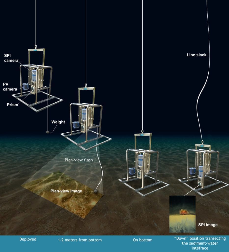
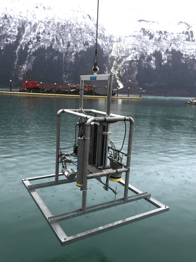
Sediment profile and plan view imaging (SPI–PV) is a cost-effective way to map physical, geochemical, and biological seafloor conditions. The high-resolution SPI–PV camera captures collocated images of the upper sediment column in profile and the seabed in plan view.
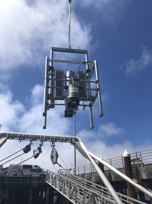
The SPI–PV System

How It Works

The SPI–PV system is lowered to the seafloor. First, the plan view image of the seabed is triggered by a weighted bounce switch. When the frame lands, the SPI camera prism sinks into the sediment—collecting a profile image of the bottom. The entire system is then lifted up and can be “pogo-sticked” along the seafloor to quickly collect multiple bottom SPI–PV image sets. The system uses internal batteries for power, so deployment is easy from any vessel of opportunity with a standard winch.


What It Sees

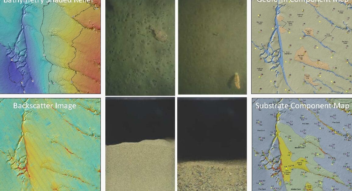
SPI is the only tool that obtains high-resolution images of the top 20 cm of the sediment column without disturbing stratigraphic features or animal–sediment relations. This unique perspective complements all other seafloor mapping techniques (e.g., multibeam echosounder, side-scan sonar, towed video) by obtaining detailed, fine-scale information on surface sediment characteristics

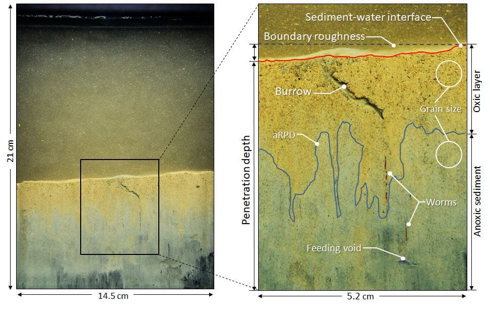
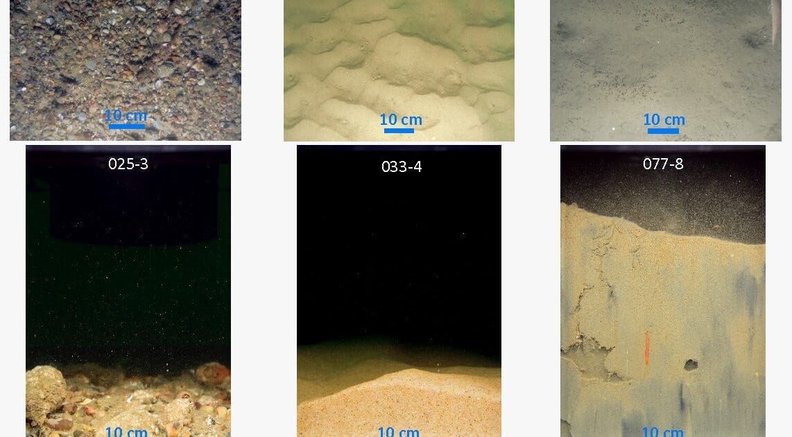
The annotated SPI image shows physical/geochemical features (penetration depth, boundary roughness, grain size, and the apparent redox potential discontinuity [aRPD] depth) and biogenic features (worms, feeding void, and burrow) that can be observed and measured in the images.

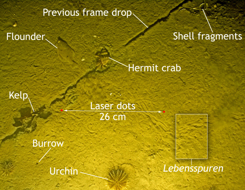
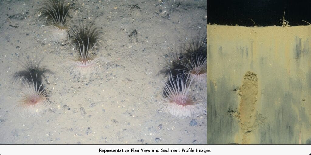
Plan view images collocated with the SPI images provide a landscape view of the seabed and complement the SPI information. The above image shows physical features (grain size, shell lag deposits, anthropogenic disturbance) and biological features (flounder, urchin, hermit crab, and lebensspuren).


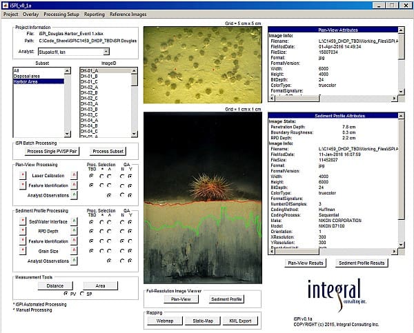
SPI and AI for Automated Image Analysis

Measurement of key features is easy and semi-automated with our integrated image analysis platform, iSPI. Designed and developed by Integral, this advanced software provides a graphical user interface that allows the image analyst to measure and add descriptive comments for key features. Deep learning techniques are incorporated, automating or semi-automating the identification and measurement of key features, such as grain size and biogenic structures.

Selected Projects

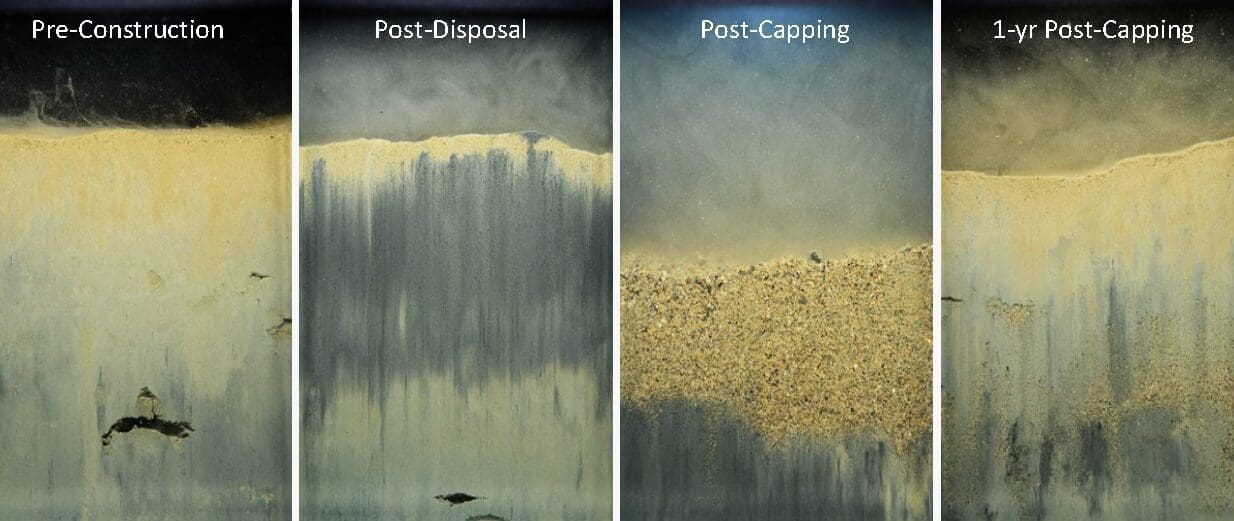
Sediment Remediation Monitoring

Kalamazoo River, MI

Bottom-feeding activities by fish, such as invasive carp, can disturb surface sediments and impede the natural recovery of contaminated sediments. Carp were removed from a Michigan Lake in an effort to to foster natural recovery. SPI technology is a key tool being used to evaluate the success of this novel contaminated sediment management strategy. The SPI camera is being used as a surrogate static-load penetrometer, and relative SPI prism penetration depths across the lake system and over time (pre- and post-carp removal) are being used as a measure of bed consolidation.

For this application, the SPI camera was purposely set up to over-penetrate into the soft sediment bed taking multiple images on descent. These images were then stitched together (blue line) to provide continuous sediment profiles as deep as 32 cm below mudline.


Dredged Material/Contaminated Sediments

Douglas Harbor, Alaska
A planned harbor renovation required dredging and transport of approximately 30,000 cubic yards of mercury-contaminated sediment to a disposal site. We collected and analyzed approximately 1,000 images during four SPI–PV site surveys. The primary objective of the SPI–PV surveys was to accurately map the disposed dredged material and evaluate the success of sand cap placement, cap stability, and benthic community recolonization over time.

This time series shows the baseline conditions, the distinct dredged material and cap deposits, and the new fine-grained sediments deposited onto and mixed into the sand cap layer 1 year after construction.

Scale: width of images = 14.5 cm.

Benthic Habitat Mapping

PacWave Energy Test Site off Newport, OR
A seafloor survey approach for generating detailed benthic habitat maps at offshore renewable sites was developed with a grant from the U.S. Department of Energy. This approach combined multibeam bathymetry and acoustic backscatter mapping with SPI–PV imaging as a rapid, cost-effective protocol. A primary technical innovation was the development of image processing software that automatically identifies and measures key features in the images.

Baseline Environmental Studies

Offshore Wind Farms, U.S. East Coast

Offshore wind (OSW) lease areas and export cable routes have been proposed up and down the U.S. east coast. SPI–PV seafloor surveys have become an integral tool in establishing baseline benthic physical and biological conditions at these sites. Geophysical and geotechnical investigations are used to evaluate seafloor conditions to support engineering and hazard assessment. Proponents typically combine multibeam mapping with seafloor imaging to rapidly develop quantitative seafloor maps at detailed spatial scales. To date, Integral has successfully conducted nine baseline SPI–PV surveys for multiple wind farm projects off the East Coast.


Offshore Oil and Gas Environmental Assessments

Gulf of Mexico

As oil and gas sites are abandoned, SPI–PV technology is used to map drilling muds and splays in the vicinity of drilling sites, while also obtaining synoptic data on benthic habitat and physical, geochemical, and biological conditions. Along with the benefit of capturing dense spatial coverage and relatively rapid information return, this capability has made SPI–PV surveys a key tool in this sector. For example, SPI–PV imaging is a monitoring tool required by ASEA (Mexico’s Agency for Safety, Energy, and Environment) for offshore oil and gas activities.

Key Contacts

Eugene C. Revelas Senior Science Advisor

Bio

Craig A. Jones, Ph.D. Managing Principal, Business Director - Marine, Coastal, Climate, and Technology Services

Bio