Oceans
Oceans, coasts, and coastal estuaries provide critical economic, environmental, and social services for our clients. We bring multidisciplinary expertise to develop practical solutions for our clients’ needs, from best practices in forecasting and monitoring, to efficient and effective permitting, to supporting sustainable development in challenging aquatic environments.
Coastal Climate Risk & Resilience
Coastal Climate Risk & Resilience takes shape in a variety of ways, from risk assessment and modeling to resource management and nature based solutions. Integral evaluates the costs, benefits, and trade-offs among different adaptation approaches, leading to sustainable community planning and resource management. We understand how to measure, analyze, and explain the interactive processes driving change today, and we have the tools to project how the interactions will evolve in the future.
Coastal Vulnerability and Risk Assessment | Coastal Adaptation Planning | Coastal Site Characterization and Assessment | Coastal Economics | Post-event Assessment and Resilience Planning | Estuary Management | Regional Sediment Management | Nature Based Solutions | Coastal Hazard Modeling
offshore energy
The offshore environment presents unique challenges throughout all phases of offshore energy projects. We support offshore energy projects worldwide with clear planning and implementation of environmental, geophysical, and meteorological and oceanographic assessments. Together with our clients, we develop insightful project solutions. By delivering safe, efficient, and practical offshore site investigations, our results support permanent solutions that work.
Oil and Gas | Offshore Wind
RENEWABLE energy
As marine renewable energy technologies, such as marine hydrokinetic energy and offshore wind farms, evolve from pilot to commercial scale, accurate assessment of site-specific resources and potential environmental effects is essential for permitting and project implementation. Our innovative tools quantify the relationships between the environment and device arrays, which help maximize energy production while minimizing environmental and ecological effects.
Marine Hydrokinetic Energy | Offshore Wind | Metocean | Modeling | Currents | Waves | Sediment Transport | Coastal Ecology
climate change
Climate change is driving planning, operational, and infrastructure decisions for our clients. We implement state-of-the-art forecasting and monitoring of coastal impacts, develop carbon footprint strategies, and offer insightful evaluations of greenhouse gas mitigation options to understand changes in the physical, regulatory, and social environments. By applying dynamic insight, we achieve sustainable solutions in an evolving planet.
Sea Level Rise | Coastal Hazard Analysis | Climate Change
oceanography
Oceanographic processes—whether physical, chemical, or biological—affect all aspects of the Blue Economy. From maritime safety to coastal planning, we develop robust client solutions in environments ranging from coastal and estuarine waters to the deep ocean. Our comprehensive understanding of physical, biogeochemical, and acoustic processes, coupled with advanced monitoring and modeling tools, enables us to craft innovative approaches for complex ocean projects.
Modeling | Currents | Waves | Sediment Transport | Metocean | Acoustics | Water Quality | Real-Time Data
Monitoring TECHNOLOGIes
The ocean environment is energetic and incredibly diverse, which makes collecting the data to support design, permitting, and execution of ocean projects complex and challenging. We know the value of having the right data to meet project needs. That’s why our team has led the way in developing and applying innovative tools and techniques to collect the necessary data to understand complex ocean processes and human–ocean interactions.
ADCP | OPTICS | Metocean | Marine Hydrokinetic Energy | Offshore Wind | Hydrodynamics | Acoustics | Sediment Profile Imaging | Remote Sensing | SEDflume | Multiparameter Water Quality Sonde | Spotter | Drifter | Laser Particle Sizer | Real-Time Systems
Load More
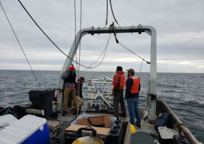
Site Characterization
To accurately characterize sediment transport, two of the most important parameters to understand and quantify are the sediment erosion rate and the critical shear stress. Integral’s SEDflume directly measures these parameters in sediment cores obtained in the field or reconstructed in the laboratory. With SEDflume, our team can get the data needed to answer important environmental questions—leading to better site decisions.
Site Characterization | Remedial Investigation/Feasibility Studies | Sediment Transport | Data Collection | Laboratory Analyses
Erodibility Studies
SEDflume helps measure the erosion rate at site locations. Using SEDflume, we can determine the critical shear stress for erosion and develop a relationship between environmental forces and erosion rates. SEDflume applies an increasing range of shear stresses to a collected sediment core to measure associated erosion rates. This process is applied multiple times over the length of a sediment core to develop a profile of bed properties associated with depth. Supplemental data—including particle size distribution via laser diffraction, bulk density, and loss on ignition—provide a robust data set.
Sediment Transport Models | Spatial Analysis | Geotechnical Studies | Sheer Stress | Erosion Rates
Laboratory Services
We maintain mobile and fixed laboratories to support SEDflume and sediment characterization studies. Samples collected from rivers, lakes, estuaries, and deep ocean systems are analyzed in Integral’s mobile SEDflume laboratory or securely shipped and processed at Integral’s fixed sediment laboratory in Santa Cruz, California.
Our equipment includes a Beckman Coulter LS 13-320 laser diffraction particle size analyzer, which provides sediment size ranges from 0.4 to 2,000 microns. Samples are analyzed for loss on ignition, wet and dry bulk density, and total suspended solids via standard ASTM methods. We also perform consolidation and settling studies.
Sampling | Analysis | Water Content | Bulk Density | Laser Diffraction Analysis | ASTM Methods | Total Suspended Solids | Consolidation and Settling Studies
Surface and Water Column Characterization
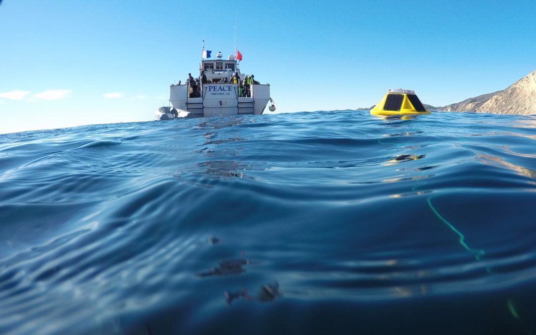
Whether our clients need data at the water surface or from the deepest sediment bed, we offer a range of oceanographic instrumentation to collect it. Wind-driven and long-period surface waves are measured with an array of wave buoys and acoustic sensors. Within the water column, key factors such as velocity, total suspended solids, salinity, temperature, dissolved oxygen, and turbidity can be measured. Metrics on these constituents can help determine flux of material through a system over time, calibrate and validate numerical models, and inform analyses of site-specific long-term trends.
Water Quality Monitoring | ADCP | Acoustics | CTD | Coastal Monitoring | Ocean Waves | Data Collection | Wave Buoy
FEATURED STAFF MEMBER
Grace Chang, Ph.D.
Senior Science Advisor, Technical Director, Marine Sciences and Engineering
Dr. Grace Chang is a consultant in limnology and oceanography. She has more than 20 years of experience performing site assessments, including hydrodynamics, sediment transport, particle dynamics, and marine and hydrokinetic energy. Dr. Chang has managed programs involving field operations, data processing and analysis, and numerical modeling for environmental characterization, and scientific research.
related case studies
recent news and articles
EPA Releases Final Drinking Water Standards for PFAS Chemicals
On April 10, 2024, U.S. Environmental Protection Agency (EPA) announced its final National Primary Drinking Water Regulations for the following six per- and polyfluoroalkyl substances (PFAS): perfluorooctanoic acid (PFOA), perfluorooctane sulfonic acid (PFOS),...
Integral Consulting Selected to Conduct Crucial Sea-Level Rise Study for Santa Cruz County
Integral Consulting Inc. has been selected to conduct a crucial sea-level rise study for Santa Cruz County, aiming to address the significant impacts of climate change along the county's 32-mile coastline. This decision seeks to explore the economic, environmental,...
Manufacturers’ Proposals for Currently Unavoidable Uses (CUU) of PFAS Due to Maine DEP by March 1, 2024
The state of Maine is one of a handful of states regulating PFAS in products. In 2021, the Maine Legislature enacted An Act to Stop Perfluoroalkyl and Polyfluoroalkyl Substances Pollution. On January 1, 2023, Maine began prohibiting the sale of carpets or rugs and...